Synoptic Prediction System
- The implementation was a mixture of commercial proprietary software and bespoke proprietary software.
- Open source versions are available should others want to repeat this using them.
MEDALUS III was the third phase of a series of large European Commission funded efforts to research Mediterranean Desertification and Land Use Change. This third phase was made up of four interconnecting projects. Details of the Regional Indicators project can be found on The Cordis Website under code ENV4950121 and The Internet Archive Wayback Machine that serves up the old Medalus web site content. Topic 9.1 GIS-based Socio-Economic Modelling at Regional Scale was part of Module 9: Regional Economic and Social Approaches to Desertification. Project start date: 1996-01-01. Project end date: 1999-06-30. Stan Openshaw was the Principal Investigator. Ian Turton and Tim Perée assisted with the first half of the project. Andy Turner assisted with the second half. The research involved the development of a prototype Synoptic Prediction System (SPS) to link physical, climatic and socio-economic data in order to make predictions of land use change and land degradation for the Mediterranean region of the EU for around 50 years hence at a spatial resolution of approximately 1 km 2. This Web page outlines how this was done, presents some results from the various tasks involved, and offers some suggestions for further research. Topic 9.1 Final Report
The principle objective of Topic 9.1 was to incorporate a socio-economic dimension to the MEDALUS III physical models which relate to land degradation in Mediterranean region of the European Union. There were various ways to approach this integration task, the four stage methodology implemented involved:
Environmental sensitivity is a dynamic concept that involves many complex interactions between fairly well understood physical and climatic systems, and various undefined and poorly understood social, economic and political systems. Predicting the impacts of global climate change on land use patterns and presenting the results in a form that decision makers can understand is not straight forward. Mapping geoenvironmental variables which describe the geographical environment (for example; rainfall, temperature, vegetation cover, biomass, soil type, land use, population density, subsidy rates) and comparing the maps by eye is insufficient to explain or comprehend the process adequetly. However, at the time it was impossible to represent all the processes mechanisms underlying the complex space-time interactions which result in land degradation in a detailed dynamic computer model that could be run fast enough to forecasts the effects of imposing climate change. The necessary understanding of these geoenvironmental interactions and the data simply did not exist. We believed that some form of synoptic modelling and map based visualisation was perhaps the only contemporary available means to integrate the physical, climatic and socio-economic data so as to represent the entire complex system in a way which was helpful to geographers investigating the problem and which also produced output which policy makers and other non-geographers could readily appreciate.
The effects of climatic change and socio-economic development on land use patterns which relate to land degradation are massively complex, scale sensitive and not obvious. Intricate relationships exist between the climate and the distribution and motivation of people who make agricultural land use decisions which affect land degradation. Decisions to change crop patterns, abandon cultivation or abandon agriculture altogether are made in highly specific contexts. Forecasting when these decisions will affect land degradation is very difficult and was probably impossible at any reasonable level of uncertainty with contemporary data (even for a single farm). As a consequence, all that can could be expected to be done in any reasonable way was to produce broad brush results which were generally right and which could serve as the foundations for more detailed analysis to be undertaken as better and more improved data became available and as greater understanding of the process of land use change and land degradation is gained.
For the integration of physical, climatic and socio-economics to be of any value for regional scale decision making and awareness raising in the near future we believed that it had to be undertaken at a spatial resolution of about 1km and produce forecasts for about 25-50 years time. To attempt this, some way to identify the principal relationships between key physical, climatic and socio-economic variables mainly responsible for contemporary land use patterns was needed. Using a model of these relationships it was felt that (by assuming that many varying factors stay constant) the first bold educated scientific estimates of land use for about 50 years hence using forecasts of the contemporary predictor variables could be produced. By translating the expected land use changes into land degradation risk surfaces and combining these with other measures of environmental risk it was further expected that reasonable estimates of relative land degradation could be made.
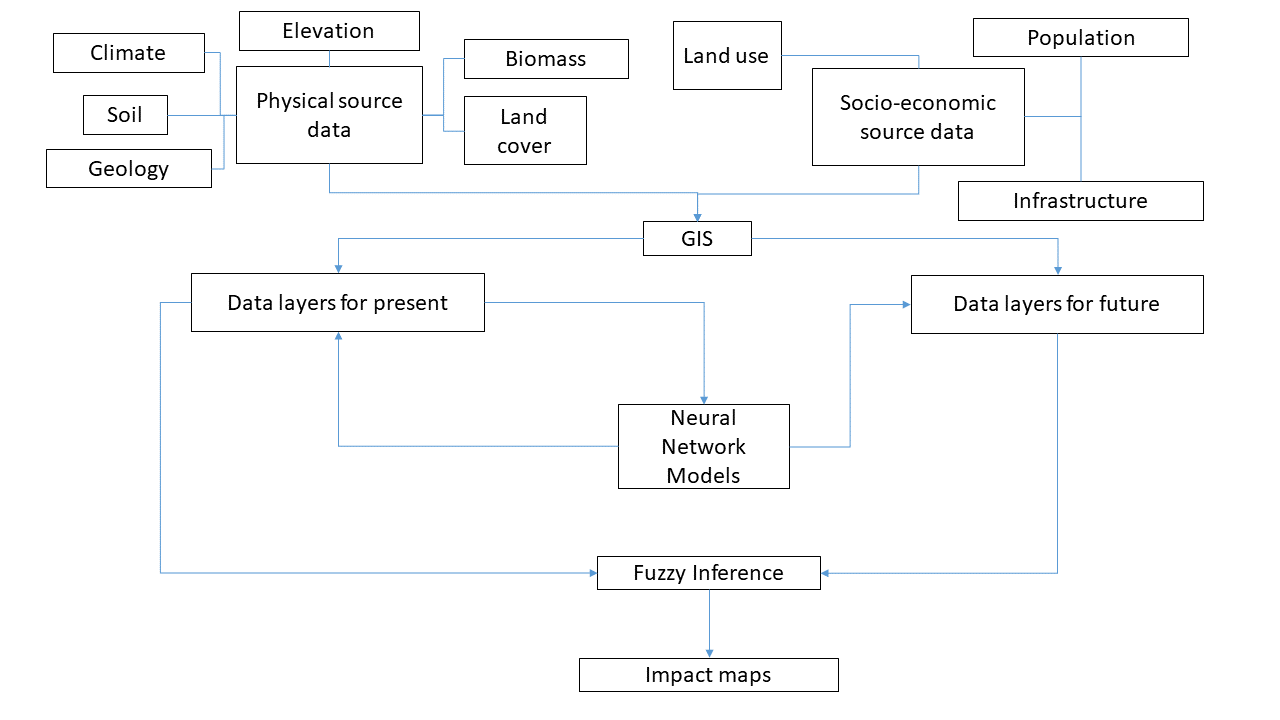
To explore the nature of geoenvironmental interations relating to land degradation we have argued that a model of land use change would be extremely useful. In the early stages of developing this model it became clear that it would have to be synoptic given the nature of the available data. Despite this imposed generality we believed such a model could at least be used in gaining a greater appreciation and understanding of the complexity and sensitivity of the processes invlolved. The prototype Synoptic Prediction System (SPS) that was developed was designed to model and investigate the nature of land use patterns and forecast the likely impact of land degradation driven by global climate change. The prototype SPS modelled geoenvironmental interactions in a relatively objective manner by using neural networks to represent and interpolate spatial data patterns making a minimum of apriori assumptions about the nature of these patterns. Fuzzy logic based inference methods were employed to incorporate geographical understanding relating to environmental risk and translate differences in the neural network based land use classifications to produce synoptic land degradation indicators. A major assumption has been that different types of land use and land use change represent varying levels of land degradation risk. The hope is that the SPS will develop into a practical educational tool which raises awareness of environmental sensitivity, improves land use planning and helps devise strategies to mitigate land degradation problems. The SPS provides a basic framework for a scenario based forecasting system that can be updated and extended as new and improved input data becomes available. Although the modelling involved is geared specifically to produce a set of agricultural land degradation forecasts for the Mediterranean region of the EU, there is no reason why it could not be adapted to make similar forecasts for other areas at more detailed scales provided sufficient data is available.
Ideally agricultural subsidy information would have been used to drive land use change and land degradation risk forecasts. Unfortunately the data were too expensive to acquire, meta data was poor and the quality of the data was unknown.
In summary, the synoptic strategy implemented was not designed to directly attempt to model geoenvironmental interactions with future socio-economic systems because this was believed to be almost impossible at the time in any non-trivial manner. Instead it was an attempt to classify the likely relative broad scale effects of climate change on land use patterns and translate the expected changes in land use patterns into land degradation terms. The choice of the word synoptic reflects the generality of the approach both in terms of the assumptions that are made, the variables that are used as inputs and the spatial and temporal frame of its operation. The modelling basically involved classifying contemporary agricultural land use, forecasting future agricultural land use, creating land use change related land degradation risk indicators and related scenario based land degradation forecasts. The SPS is a prototype system, it is a first bold attempt at modelling land degradation at this scale with a GeoComputational modelling approach and although we believe that the framework offers a useful approach to assessing the possible impacts of climatic change on land use, the quality of the results so far really only reflect the quality of the data inputs that have been used.