
Introduction
[outline]
Welcome to the course! This page will introduce you to the course and get you up and running with "Programming for Geographical Information Analysis: Advanced Skills".
The course is designed to move you from being a basic-level programmer to being a programmer who can work with some of the classic techniques used by spatial analysts. The course works through from data processing, through analysis and visualisation, to modelling – the classic analysis sequence.
Ready? Great! Then we'll get started!
First up, the slides to the right repeat the introductory lecture given, including all the important spoken info as notes below the powerpoint slides.
Course introduction (powerpoint)
For the first part of the course, we're going to look at data processing. The majority of this will be spent looking at how we might program a GIS. In the core course, displayed some raster GIS data, but we might also want to program an off-the-shelf GIS to do additional processing or analysis for us. We're going to look at ArcGIS.
ArcGIS is a huge system, with lots of ways of programming it and lots of areas of activity one could program. However, the core of it is the data it holds, so we're going to get to the point at which we can programmatically get hold of data, view it, and manipulate it.
We will, however, also give you additional Arc code, so you can see how data analysis is done, particularly the analysis of networks. Once we've finished looking at Arc, we'll then move on to data in databases.
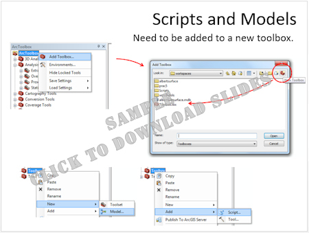
First, however, we'll look at the multitude of ways in which Arc can be programmed.
Further info:
Using AML as scripts.
For additional materials on AML and ArcWorkstation, see the
extra materials page.
VBA is finally dead
from ArcGIS 10.5
In the absence of VBA, there's the
.Net language alternative
For the fullest programming, there's this Java and .Net guide
Note that if you're looking at older materials online, with the introduction of ArcGIS 10.1 the names of the software packages are changed.
Introduction to Arc Programming (powerpoint)