GEOG3150 Semester 2
Lecture 8
Simulation for Policy Modelling
Dr Nick Malleson
Dr Alison Heppenstall
Click here for full screen
Thanks to Andrew Crooks for lots of this material.If you would like to see more of Andrew's work, have a look at his fantastic blog (called GIS and Agent-Based Modelling) and his YouTube channel.
Also thanks to Dr. Sara Manzoni for ideas about crowd simulation. See Sara's presentation (entitled "A multidisciplinary approach to crowd studies" here).
How to use these slides
These slides are made using HTML, so they need to be read on-line. You can use the arrows in the bottom-right corner to move between slides, or press the right/left arrows on your keyboard. Pressing escape gives an overview of all slides.
There are also notes for some of the slides. To see these, either print out
the slides (instructions below) or press the 's' key. This
puts you into a different mode that will show notes alongside slides.
If you would like to print them out for offline reading, or save them
as a pdf, you need to add '?print-pdf' to the end of the URL, like so:
http://www.geog.leeds.ac.uk/courses/level3/geog3150/lectures/lecture8/lecture8.html?print-pdf
Then you can print as normal (e.g. File -> Print). Depending on the version of your browser, you might also need to select'landscape' paper type..
Important: printing only works using Google Chrome
Recap: ABM and Geography
Reasons to model:
Explanatory
Predictive
The reason for modelling will influence your decisions over the modelling environment
Different types of 'geography'
Grids
Continuous space
Social network?
GIS
Recap: ABM & GIS

Loose coupling
The GIS and the model do not interact directly
Tight coupling
The GIS and model are integrated
Loose coupling is more efficient and flexible, but it can make interacting with the model more difficult.
Outline: Simulation for Policy Modelling
Modelling for Emergency Planning
Models are simplifications of reality
Advantages
Clean (focus on important aspects of the world)
Flexible (changing assumptions)
Scaleable (designed to appropriate scale)
Safe (no risk to real people)
Ethical (can test different scenarios)
Decision-makers are unlikely to be experts.
Models can be valuable for teaching, planning, understanding..
Modelling Emergencies
Physical models / games
'Board games' that simulate the occurrence of an emergency event.
Used by managers to practice their response, coordination and improvisation.
Source: Alexander (2002)
Computer Models
(Probably) more common than physical models these days
Computers simulate the effects of an emergency event
Warning: rubbish-in, rubbish-out
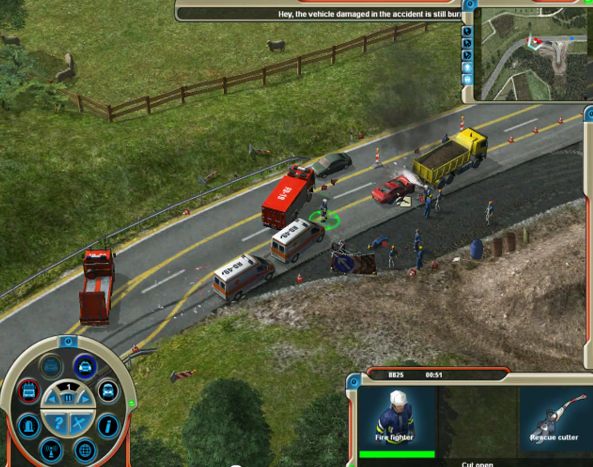
Screen shot from the computer game 'Emergency 2012'.
Pedestrian / Crowd Models
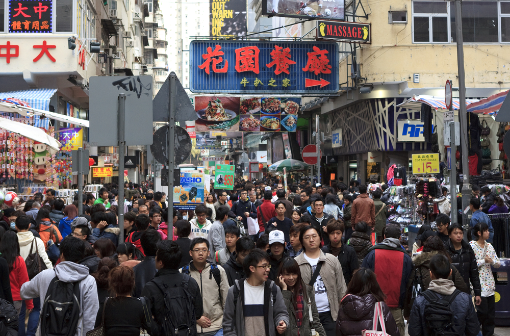
Huge global migration to urban areas
The proportion of people living in cities is estimated to rise from 40% in 1990 to 70% by 2050 ( WHO)
Need effective tools to understand pedestrian movements
Under 'normal' conditions: walking around the city and in buildings
And 'exceptional' conditions (e.g. riots, crowds, emergencies, etc.).
Agent-based models ideally suited
Virtual laboratories
Test new architectural designs
Experiment with (emergency) scenarios
Educate / inform policy makers
Building / Space Design

Increasingly important to understand how people use buildings, and how designs impact on safety.
Methods are needed to adequately test different designs
And understand how people might behave under emergence situations
Computer simulation can provide a means for emergency services to monitor, identify, and mitigate vulnerabilities (Cova, 2005)
Examples
Airports, railway stations
Offices
Shopping Centres
High-density residential areas
Cinemas, theatres, sports stadiums, music venues
etc.
Emergency Management
There are complex, inter-related factors that determine how quickly and efficiently a space can be evacuated.
Need to understand relationships between:
Building configuration (e.g. door codes, space configuration, escape routes, exits)
Environmental factors (e.g. heat, smoke)
Emergency procedures (e.g. training, signage, standard procedures)
Human behaviour (e.g. age / demographics, responses to cues, social networks, walking speeds).
Outline: Simulation for Policy Modelling
Modelling crowds - Aggregate
You want to build a model to represent the behaviour of a crowd
List some of the aggregate/macro features of a crowd that you would like to be able to represent in a simulation (think about how to validate the model).
Number of people (static or dynamic)
Crowd density (people per square meter)
Flow, pressure, rate of increase/decrease in crowd size
Movement of groups
What type of modelling method would best represent these characteristics?
Thanks to Dr. Sara Manzoni for these ideas. See Sara's presentation (entitled "A multidisciplinary approach to crowd studies") here.
Modelling crowds - Individual
You want to build a model to represent the behaviour of a crowd
List some of the individual-level features of a crowd that you would like to to be able to represent in a simulation.
Movement speed under different conditions
Queuing
Streaming (remember the emergence video in lecture 4)
Formation of groups
What type of modelling method would best represent these characteristics?
Thanks to Dr. Sara Manzoni for these ideas. See Sara's presentation (entitled "A multidisciplinary approach to crowd studies") here.
Modelling crowds - Developments
Changes in computer storage and processing power have spurred changes in modelling approaches
As you might have guessed, individual-level methods have become popular, partly because they can include:
Heterogeneous characteristics
Heterogeneous behaviour
Adaptation to local conditions (different behaviour under different conditions)
Memory / learning - making decisions based on past events
Bounded knowledge of the environment
Bounded rationality
... etc ...
For example, see Castle (2007)
Collecting data about crowds
Data are required for preparation/understanding, calibration and validation.
Data can be collected in various ways:
Qualitative methods
Observing crowds directly
Interviews / questionnaires
Stalking!
Quantitative methods
TV cameras (computer vision)
GPS devices
Sensor networks
Satellite images
Smart phones
Gathering information about crowds
Outline: Simulation for Policy Modelling
Example equations from Helbing (1996).
Fluid Dynamics and Social Forces
E.g. Helbing (1996) and Helbing and Molnár (1995)
Use dynamic equations to model traffic.
Based on basic laws of acceleration and interaction.
Analytical (mathematical) solutions, not simulation.
'Social Force' model.
Represents the internal motivation of the individuals to perform certain actions (movements)
Influences their velocity, acceleration, distance
Magnetic Model
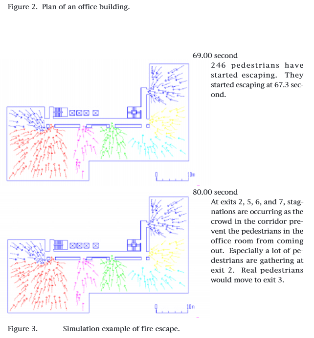
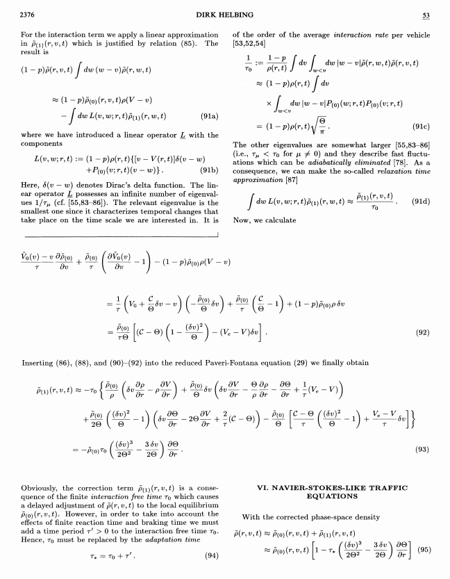
Emergency Evacuation. Source: Okazaki and Matsushita (1993)
E.g. Okazaki and Matsushita (1993)
Pedestrians and obstacles are positively charged (repel)
Exits are negatively charged (attract pedestrians).
Experiments are used to explore pedestrian behaviour under different scenarios:
Evacuation from an office building
Movement of pedestrians in 'queue spaces' (a railway station a ski resort hotel).
Magnetic Model
Queuing behaviour. Source: Okazaki and Matsushita (1993)
Magnetic force of attraction between pedestrians and exits:
F = k * (q1*q2) / r
Does anyone recognise this form of equation?
Not 'human behaviour', but good enough?
How might this approach be viewed by a critical human geographer?
Agent-based crowd models
Configuration of the museum model. Source: Pluchino et al. (2014)
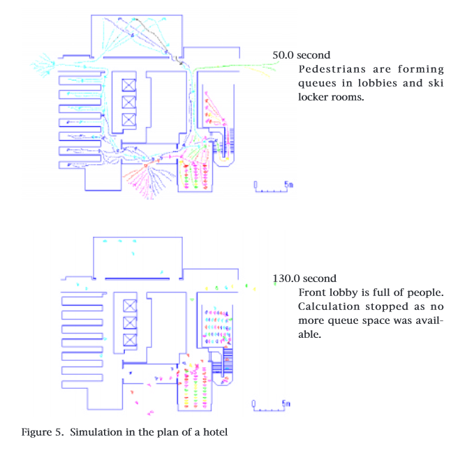
E.g. Pluchino et al. (2014).
Model is available on OpenABM.
Explores both optimal number of visitors under normal conditions and evacuation times under emergency conditions.
Agents are fully autonomous with some level of cognition and/or the ability to learn
Able to account for emergent / unintuitive outcomes
e.g. herding behaviour that unintentionally leads to greater congestion)
Example Evacuation Model
This is a Second Life pedestrian evacuation model
The rules that govern the agents are a lot more complicated than the 'classic' models (e.g. the Game of Life and Schelling's Segregation Model)
This clip shows how agents exit a building once an alarm is sounded.
Outline: Simulation for Policy Modelling
Traffic Models
Cars have become the dominant form of transport in many cities
There are a number of questions to explore:
The impacts of new roads or tolls on existing roads
New housing developments
Construction of new buildings / facilities (e.g. shopping centres, office parks, etc.)
Evacuation scenarios
The impacts of schemes to alter transport behaviour (e.g. encourage public transport use).
etc.
Motivation for agent-based traffic models is similar to pedestrian models
Homogeneity, behaviour, emergence, etc.
Abstract Models
As with other phenomena, abstract models can be useful to explore the fundamental dynamics of traffic.
Understand influence of speed, acceleration/deceleration, distance, etc. on emergence of traffic congestion
E.g. Basic traffic model in NetLogo
Waves of traffic emerge as cars begin to cluster together and slow down.
Abstract Models
The NetLogo model seems to represent real life reasonably well!
Source: the Mathematical Society of Traffic Flow.
Environmentally realistic: MATSim
http://www.youtube.com/watch?v=2HwRXbJ4ZMI
The video shows various activities performed during the day for 10 percent of the whole Swiss population.
Multi-Agent Transport Simulation (Horni et al.,2009)
Applications
Different types of journey (e.g. shopping, work, leisure)
Different cities (Zurich, Berlin, Toronto, others ..)
Individual behaviour plans for each virtual person (agent)
Individuals compete for slots on the infrastructure
Agents optimise behaviour with trial and error
Model must run a number of times
PTV Vissim
A commercial traffic simulation program.
The video shows an experiment with the design of a complicated intersection.
Modelling Traffic: Summary
Understanding traffic is crucial for urban sustainability and quality of life
(Agent-based) Models provide the tools to explore traffic solutions with policy makers
Strong links with 'Smart Cities' agenda (recall the Smart Cities lecture)
IBM and Stockholm 'Green Capital' intelligent traffic systems.
Audi's Affective, Intelligent Driving Agent (video here).
Outline: Simulation for Policy Modelling
Recognising Complexity in Bali
Attribution: Nick Leonard (CC BY-NC-SA 2.0)
Recognising Complexity in Bali
Something quite different to finish.
Scenario:
1970s 'green revolution' dramatically changed farming practices in Bali (Indonesia)
Ancient water temple rituals abandoned in favour of modern intensive farming, more frequent harvests, pesticide use, etc.
It was a disaster
Steven J. Lansing's simulation model helped to show how an organised farming system can emerge from the seemingly random, ritualistic behaviours of individual water temples.
This is a great example of use of Geocomputation technique to better understand complexity in the real-world and provide policy recommendations.
Important to note that there are divergent explanations for the Bali system.
E.g.: Falvo, Daniel J. (2000). On Modeling Balinese Water Temple Networks as Complex Adaptive Systems Human Ecology 28(4): 641-649
There is also a NetLogo model that you can experiment with:
Lansing Presentation
YouTube: http://www.youtube.com/watch?v=kZLLGCaz74M
TEDx: http://tedxtalks.ted.com/video/Perfect-order-recognizing-compl
Summary
(Agent-based) simulation is an extremely useful technique for predicting pedestrian and vehicle movement
Captures emergent phenomena
Allows for heterogeneity in individual characteristics and decision making
Models provide a tool to educate and collaborate with non-technical experts
They make it possible to test new designs in a safe environment
More broadly, these types of simulations can help to show how seemingly complex/random processes lead to higher level order.
They change the way that we view and understand the world.
And, when properly communicated, can radically alter policy.
Next lecture & homework
For the next lecture I'm piloting a 'flipped classroom' and 'peer instruction', rather than a traditional lecture
This experiment is part of an ongoing teacher-training course that I'm doing
The basic idea is to encourage students to do some homework before the lecture
Lectures can then be more interactive and help you to think.
Before the next lecture (after Easter) please the following:
Evans, A., A. Heppenstall and M. Birkin (2013) Understanding Simulation Results. In B. Edmonds and R. Meyer (eds) Simulating Social Complexity. Springer.
Available on the VLE
There is also some guidance and questions here: http://www.geog.leeds.ac.uk/courses/level3/geog3150/lectures/lecture9/
References
Alexander, D.,E. (2002) Principles of Emergency Planning and Management. Terra Publishing; Harpenden.
Batty, M. (2003), Agent-Based Pedestrian Modelling, Centre for Advanced Spatial Analysis (University College London): Working Paper 61, London, UK (pdf).
Castle, C. (2007) Guidelines for Assessing Pedestrian Evacuation Software Applications Centre for Advanced Spatial Analysis (University College London): Working Paper 115, London, UK.
Cova, T. (2005) GIS in Emergency Management, in Longley, P.A., Maguire, D.J., Goodchild, M.F. and Rhind, D. (eds.), Geographical Information Systems: Principles, Techniques, Applications, and Management pp. 845-858. New York: John Wiley and Sons
Helbing, D. (1996), Gas-Kinetic Derivation of Navier-Stokes-like Traffic Equations, Physical Review E 53(3): 2366-2381. [pdf]
Helbing, D. and Molnár, P. (1995) Social Force Model for Pedestrian Dynamics, Physical Review E 51(5): 4282-4286. [pdf]
Horni, A., Scott, D., Balmer, M. and Axhausen, K. (2009) Location Choice Modeling for Shopping and Leisure Activities with MATSim Combining Microsimulation and Time Geography. Transportation Research Record: Journal of the Transportation Research Board 2135 87�95.
Lansing, Stephen J. (2006) Perfect Order: Recognizing Complexity in Bali Princeton University Press.
Okazaki, S. and Matsushita , S. (1993) A Study of Simulation Model for Pedestrian Movement with Evacuation and Queuing, in Smith, R.A. and Dickie, J.F. (eds.), Engineering for Crowd Safety: Proceedings of the International Conference on Engineering for Crowd Safety, London, UK, pp. 271-280. [pdf]
Pluchino, A., C. Garofalo, G. Inturri, A. Rapisarda and M. Ignaccolo (2014) Agent-Based Simulation of Pedestrian Behaviour in Closed Spaces: A Museum Case Study Journal of Artificial Societies and Social Simulation 17 (1) 16 http://jasss.soc.surrey.ac.uk/17/1/16.html
Patel, A. and A. Hudson-Smith (2012) Agent tools, techniques and methods for macro and microscopic simulation. In A.J. Heppenstall, A.T. Crooks, L.M. See & M. Batty (Eds.), Agent-based models of geographical systems. Berlin: Springer, chapter 18. (Available through Leeds library).