Return to GeoComputation 99 Index
Yu Jiang
Institute for Technology Development, Building 1103, Suite 118, Stennis Space Center, MS 39529 U.S.A.
E-mail: yjiang@iftd.org
This paper introduces a simple but practical method of calibrating airborne hyperspectral imagery acquired by a Push-broom airborne hyperspectral imaging sensor (RDACS/H3). The sensor generates imagery via a line-by-line scanning method. Usually an image generated by the RDACS/H3 has a wavy look due to the random aircraft attitude changes during the scanning process; therefore, calibration is essential before the geo-referencing process can be undertaken to match an image to a map or a reference image. Most airborne hyperspectral data lack the attitude changing information of the aircraft, which makes it is impossible to conduct the calibration by conventional means. This paper addresses the calibration problem by fitting a linear feature on a raw image to a corresponding linear feature on the reference image. This method eliminates the major wavy distortions but reserves the necessary features for the later geo-referencing process. The results proved that a wavy, distorted, hyperspectral image can be efficiently calibrated and accurately geo-referenced to match a reference image.
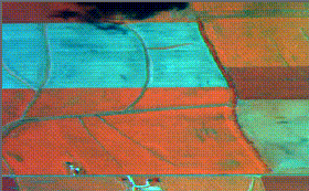
Airborne hyperspectral imagery generated by a push-broom sensor RDACS/H3 provides information of both high spectral resolution and high spatial resolution. The high resolution imagery is very useful for remote sensing in agriculture, forestry, and other fields; however, the imagery has a wavy look (see Figure 1) due to the aircraft attitude variation during the sensor scanning process. Calibration for the imagery is difficult because the information regarding aircraft attitude changes is not available, which makes the conventional calibration method that uses six external elements in photogrammetry inapplicable. Also, the wavy deformation, which does not have systematic attributes, makes statistical rectifiers, such as polynomial and rubber sheeting, lose efficiency. In other words, the raw image cannot be geo-referenced before its wavy deformation is removed.
Removing deformation means to move or place the deformed image points (pixels) to where they are supposed to be; however, on a raw image, it is unfeasible to find out the correct locations for the deformed points. A reference image (see Figure 2) is needed to provide correct locational information. With the correct information, the off-set between the raw image and the reference image becomes known; thus, calibrating to a wavy image can be undertaken by using the known off-set (see Figure 3).
|
|
|
|
|
|
|
|
|
|
|
|
Figure 1. The raw image. |
|
Figure 2. The reference image. |
Looking at a raw image, it seems that the major deformation was due to the roll of the aircraft; however, the deformation is actually the result of contributions from all of the factors that influence aircraft attitude change, such as pitch, crab, aircraft speed change, height change, etc. Removing the wavy appearance by applying compensation for the roll in order to fit the reference image must not only account for the removal of the deformation caused by the roll, but also must account for the removal of the deformations caused by the other influential factors. In other words, to force a raw image to fit a reference image is an overall measure of removing many kinds of off-set in the raw image.
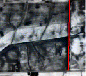
Corresponding linear features in a raw image and its reference image can be digitized on a screen to get (x, y) coordinates in ASCII format. In this project, the screen digitization was done in ERDAS image processing environment. Figure 4 illustrates the screen digitizing process for the raw image in Figure 1;
whereas Figure 5 shows the screen digitizing process for the reference image of Figure 2. The results of the screen digitizing were used to generate off-set illustrating in figure 3. The off-set was produced in ASCII format.
|
|
|
|
|
Figure 3. Off-set are generated by the difference |
|
|
between the feature lines on both raw and reference. |
When the off-set of the raw image was found, a computer program written in C language was used to apply the compensation for the raw image by using the off-set in ASCII format. The output is illustrated in Figure 6; however, it must be pointed out that the calibrated image in Figure 6 does not fit the reference image in Figure 2. To apply the compensation to the raw image to "fit" the reference image merely means that distribution of the linear feature in the raw image fits the distribution of that of the reference image. The output image actually does not fit the reference image because there are some other factors, such as pixel size differences that prevents the fitting. What was achieved in the correction processing was that the major unsystematic errors/deformation were removed; thus, the systematic errors remain unchanged. A rubber-sheeting program of ERDAS Imagine software was used to conduct the rectification of the remaining systematic errors, and the output is illustrated in Figure 7. The geo-referenced image in Figure 7 presents a good match to the reference image in Figure 2.
|
|
|
|
|
|
|
|
|
|
|
|
Figure 4. A feature line is digitized on screen for the raw image in ERDAS environment. |
|
Figure 5. A feature line is digitized on screen for the reference image in ERDAS environment. |
|
|
|
|
|
|
|
|
|
|
|
|
Figure 6. The calibrated image. |
|
Figure 7. The geo-referenced image. |
The technique discussed above was straightforward and performed efficiently. It removed deformation caused by many factors at one time. Fitting a linear feature to a reference linear feature, it seemed that there was no unwanted distortion created during the process of removing the wavy deformation. Based on the evaluation of dozens of images processed, the author did not find any unwanted deformation created. Moreover, forcing a linear feature to fit a reference linear feature actually reserves the local features, which might be useful for the later geo-reference process.
Implementing this technique is trickier than it seems to be. First, the method discussed above could only be capable of correcting images with a slight or moderate wavy look. When the wavy look becomes severe, the (x, y) coordinates acquired during the screen digitization will need a special treatment that rejects bad data. Second, due to the pixel size variance and difference, and the pitch deformation that generates uneven pixel sizes, it is tricky for a programming activity to implement the "fitting" between the (x, y) coordinates acquired from the raw image and the reference image. Any failure of matching correct coordinates will potentially create unwanted deformation.
The disadvantage of this technique is that it requires an image with at least one distinctive linear feature, or this technique becomes inapplicable. In some circumstances, multiple minor linear features can be intelligently merged as a major linear feature in order to make this technique applicable. This requires a user to have more knowledge of image processing and more flexible computer skills in data manipulation.
Despite some disadvantages, this technique is practical and productive. The author succeeded at calibrating many severely distorted images by applying this technique intelligently.
The author would like to thank Dr. Chengye Mao and David Lewis.
Richards, J. A. 1993. Remote Sensing Digital Image Analysis, Springer-Verlag, Berlin, Heidelburg, Germany.
Lillesand, T.M. and R.W. Kiefer, 1987. Remote Sensing and Image Interpretation, John Wiley & Sons, Inc.
Tan, H. Q., 1992. C Programming, TsingHua University, Beijing, China.