Cellular distance to or from a set areas classified as built-up
Description
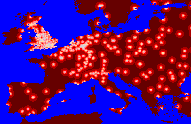
ArcView was used to assign values to each cell corresponding with the distance to the nearest built-up area, the view above shows a classification of these distance values.Source=Bartholomew's European 1-Decimal-Minute digital map data (BARTS).
Comments
- The map shows that in England the distance from a built up areas is quite small and many areas are classed as built up compared with the Mediterranean region of the EU in general. It seems likely that there is a significant variation in the interpretation of built-up areas and the resulting classification across Europe in the source data set. An example of an area which maybe expected to be classified as a built-up is Bordeux in France, especially when you consider that York in England is.
- The variation in the way built up has been defined in different regions (an inconsistency in the data source) causes problems. One way to reduce the effect of the inconsistency in later models (developed in an iterative manner) is to add new areas likely to be built-up that are currently missing to enrich the data, for example, one could add built-up areas based on a classification of population density itself derived from previous neural network output.
- Actual distance on a geographical projection is distorted some what. People used to maps of the UK based on the Great Britain grid might think this area appears a bit short and fat compared to usual on the above map. The measure of distance really being substituted as a proxy for actual distance is based on the cell distance, where the cells are not equidistant. For the initial development of the SPS it was thought best to simply use a geographical projection as a compromise of areal density, distance, location and direction distortions as the common spatial framework. The geographical projection compromises the distortions caused by projecting a surface onto a flat map to some degree. In this case, it would have been better to reproject the source data into a projection and coordinate system which minimised distance distortions, then calculate cell distances and then reproject back again so the data was consistent with the main chosen analytical spatial framework.