School of Geography
University of Leeds
UK
Richard KINGSTON, Steve CARVER, Andrew EVANS & Ian TURTON
ABSTRACT
Current research examining the potential of the WWW as a means of increasing public participation in environmental decision making in the UK is discussed. The paper considers traditional methods of public participation and argues that new Internet based technologies have the potential to widen participation in the UK planning system. Evidence is provided of the potential and actual benefits of on-line spatial decision making systems in the UK through two real environmental decision making problems at the local and regional scale.
The paper identifies key themes developing in this area of Web-based Geographical Information Systems (GIS) and provides case study examples of on-line public participation GIS (PPGIS) from inception to the final phase in a public participation process. It is shown that in certain UK planning problems and policy formulation processes, participatory on-line systems are a useful means of informing and engaging the public. This provides mechanisms for the exploration, experimentation and formulation of decision alternatives by the public in future planning processes and has the potential to bring the public closer to a participatory planning system.
The rise of the Internet and the WWW (or Web) over the past decade has created many opportunities for its use in local, regional and national democratic process. Almost every city, town and district in the UK now has a presence on the Web which offers the potential to deliver public goods and services through this relatively new media. One area where the Web can be used to great advantage is for the enhancement of participatory democracy in environmental decision making. To gain an understanding of the potential benefit and the processes by which the public could use, interact and benefit from such systems requires a comprehensive research agenda which can develop, live test and monitor such activities. The research being undertaken by the authors aims to investigate this potential in both a theoretical and practical way.
In recent years GIS have begun to appear on the Web ranging from simple demonstrations and references to GIS use, through to more complex on-line GIS and spatial decision support systems (Carver and Peckham, 1999). The level of functionality among these GIS systems is variable giving the general public, or at least those with a connection to the Web, access to a variety of both GIS systems and data of varying degrees of sophistication. There are many definitions of GIS, but a generally accepted definition is that of an advanced computer tool box for the input, storage, editing, manipulation, update, integration, analysis, visualisation and output of spatial data. Some of these systems have been developed in the research discussed here. The increased availability of GIS via the Web is becoming ever more a reality, thus the previous criticisms of GIS being an elitist technology (Pickles, 1995) may no longer be valid in the same context. GIS and the Web are ever evolving technologies and hold great potential for public use, allowing wider involvement in environmental decision making. It was noted as early as 1993 that "they can design GIS primarily for expert use or they can make them accessible to the lay professional and even to the general public" (Innes and Simpson, 1993, p.231) and it is suggested that this research has moved a step closer to realising this aim of increased accessibility.
The research discussed here has very applied characteristics and has worked closely with several organisations so that the systems developed could be live tested in real environmental decision making problems. The project worked closely with a local urban authority in West Yorkshire, Northern England, a local regeneration trust and the residents of a village called Slaithwaite to develop the first case study at the local scale. For the regional case study the Yorkshire Dales National Park Authority (YDNPA), also in Northern England provided data and expertise on a reforestation project. The regional system was live tested on residents and visitors to the National Park. A national case study is also under development with UK Nirex Ltd who are responsible for nuclear waste disposal in the UK. The use of real decision making problems is seen as the key to the proper development of Web-based GIS as this provides both a substantive focus for the research and development work and it also helps to secure widespread public interest by being grounded in something real.
This research is part of a wider programme of work currently being undertaken in UK universities and funded by the Economic and Social Research Council's (ESRC) Virtual Society? Programme. The aim of the research programme as a whole is to examine if there are fundamental shifts taking place in how people behave, organise and interact as a result of emerging electronic technologies such as the Internet and the Web.
Public participation in environmental decision making and the planning system in the UK has a relatively lengthy history. Ever since the first Town and Country Planning Act in 1947 varying degrees of public participation have existed in the UK planning system although it was not until 1969 (Skeffington, 1969) that widespread public participation became embedded in the process. Public participation in the UK planning systems tends to be based in two areas, that of plan making in the first instance and in the development control process. While this paper does not intend to analyse the methods of the public participation process in the UK a brief description of a typical scenario is outlined below. For a more detailed account of participation in both the development control process and the development plan process see Thomas (1995).
Common practice in traditional methods of public participation involves the public, or at least those with an interest, attending planning meetings which quite often involves an atmosphere of confrontation. This can discourage participation by an often less vocal majority causing public meetings to be dominated by individuals who may have extreme views. These views may not necessarily represent the wider opinions of local people. Planning meetings often tend to take place in evenings at specific times that can limit the numbers of people who are able to attend. The restricted time and also the actual geographical location of public meetings can further restrict the possibility of widespread attendance. Physical access to such meetings can lead to the exclusion of the disabled, the elderly and infirm as well as those who maybe deaf.
There are many advantages to a Web-based approach at local, regional and national public participation events. The meetings are neither restricted by geographical location nor time. Access to the information about the issues being discussed is available from any location that has Web access. The information is also available at any time of the day thus avoiding the problems associated with holding meetings only in evenings. The concept of a "24/7" (i.e. 24 hours a day, 7 days a week) access opens up opportunities for more people to participate in public consultations. With a Web-based system the public is at the end of a telephone line that enables them to make comments and express their views in a relatively anonymous and non-confrontational manner compared with the traditional method of standing-up in front of a group of relative strangers.
A Web-based system is unique in its ability to provide a 2-way flow of information from the public to the system and back again. Widespread use of the Internet and the Web is still some time away although the speed at which business, government and to a certain extent the public have adapted to using the technology is arguably faster than any other technology preceding it. As computers become more widespread especially in schools and the workplace the ability of the general public to use and feel comfortable with computers and technology will increase. Computer software for drawing and manipulating map-based software has over the past decade become much easier to understand and operate. The use of a map as the central theme of the Web-based system can potentially provide instant familiarity of the location in which the public participation process is taking place and can thus relay a lot of information quickly and understandably to a wide audience. Several pieces of research in the past have questioned the public's ability to understand a map that is essentially a 'birds-eye' view of a place (Monmonier 1996, Keates, 1996). Many people do not instantly recognise a location when it is presented to them as an areal view although as it will be shown later in the paper this did not seem to be a problem with the on-line systems developed here. One explanation for this is the ability of the user to click on a feature on the map and be interactively informed what that feature is such as a road, restaurant, community building etc. This capability in the system helps the user to familiarise themselves with the map. It is possible to provide a facility whereby a member of the public types in their postcode or street name for example and the map zooms in and centres around their home or area of interest.
Using a dynamic map (i.e. one that is interactive and provides particular pieces information about features on it) allows the user to elicit greater detail about issues and problems in hand. This type of information is impossible to provide on a traditional paper map and allows a much richer environment for the user to interact with at their own pace. A feature which was not included in any of the systems developed so far, but would have provided improved understanding for the public, would have been visual images such as photographs or even video footage of parts of the village to improve the familiarity of locations within the village. For example, photographs or artists impressions of the new canal through the car park could have been provided allowing the public to gain a better understanding of how the new canal will look in the village centre. The noise from traffic along particular roads could also be incorporated into any future systems. Examples of this can be found in the work of Al-Kodmany (1998) who uses sketches and real images from local neighbourhoods of proposed developments and Schiffer (1995) who includes digital examples of noises generated from the proposed re-opening of a disused airport.
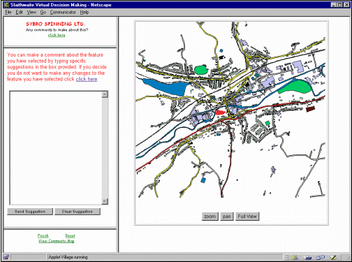
The PFR initiative provided the research project with an ideal opportunity to test out new methods of public participation by running a parallel exercise over the Web. Using the same 2km square area of land around Slaithwaite, the project developed a virtual model of the village which allowed the local community to interact with a digital map giving them relatively instant access to queries which they posed and the ensuing results. The Virtual Slaithwaite system is an on-line PPGIS facility and was arguably among the first such system available to the public which allowed a two-way flow of information. The Web browser window consists of four frames each containing particular pieces of information (see Figure 1). Members of the public can view a map of Slaithwaite, perform zoom and pan operations to assist in visualisation and navigation, ask such questions as "what is this building?" and "what is this road?" and then make suggestions about specific features identified from the map. All user input is stored in the Web access logs and is then used for future analysis and feedback into the planning process. In this manner a community database is created, representing a range of views and feeling about planning issues in the village.
The small window in the top left hand corner of the screen displays what has been selected and the 'Instructions and Help' window changes to a form which can be filled in with the comments and suggestions regarding the selected feature. If a buildings feature is selected a form is provided allowing the input of text relating to that building. Other features, such as open spaces, the river or canal provide a free form text box allowing the user to type what ever they wish. This is then 'sent' to the system for future analysis. When the user has finished, they exit the system and are provided with a series of questions asking them how they felt about using the system. They are also given the opportunity to make any further comments.
To facilitate access to the Web application the authors took eight PCs running the site to the "Shaping Slaithwaite" event. The application provided a vector map of the village, as illustrated in Figure 1 which could be zoomed, panned, and on which features could be queried. Demographic information and information on the users' feelings about the system were also collected. The application was implemented using the vector classes from "Geotools", a Java class package for the display and querying of ESRI shapefiles. The user responses were handled using perl server-side scripts and html forms. Unlike the PFR physical model, it was decided not to allow users to view other people's comments to encourage imaginative responses.
(Source: http://www.ccg.leeds.ac.uk/slaithwaite/)
There were several advantages to this method over the traditional PFR exercise. The ability to instantaneously update the database and profile users online was seen as one of the most useful advantages of the system over the traditional PFR technique. The virtual system has a long residence time allowing people to use the system anytime, anywhere. The public do not need to attend a meeting at a particular time or place, often the single most inhibiting factor in participating via traditional methods. The system allows faster collation of results from log files and the Web site can be used to disseminate results/feedback. The traditional PFR requires facilitators to remove participants suggestion flags periodically from the physical model and then put this information into a database for future analysis.
(Source: http://www.ccg.leeds.ac.uk/dales/)
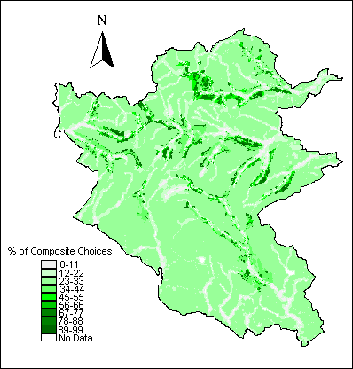
The system developed allows users to select and weight particular datasets using overlay and Multi-Criteria Evaluation (MCE) based suitability mapping. Once again the same advantages of the village case study relating to the public not needing to attend a meeting at a particular time or place was one of the advantages of this method, particularly in this larger geographical area. The system allowed an instantaneously mapped solution to where trees should be planted according to the users choices. The Dales system was live tested on the general public earlier this year with over 200 people using the system in four visitor centres dispersed around the Park. The system can also be accessed via the Internet. This system was used by professionals, residents and visitors to the national park and provided similar GIS functionality to the local case study. From this 126 valid responses were received which enabled the reproduction of the choices and weightings the individual members of the public placed on the given factors and constraints. This data was combined to produce the final composite decision map shown in Figure 2. The darker areas of the map represents those places most suitable for planting according to the 126 valid responses.
The results of the system rely on the public being truthful from when they fill in the user profile at the beginning of the system through to the factors and constraints they set. It maybe that some people do not fill this in correctly and unfortunately there is no way of ensuring correct and accurate information is collated. Out of the eight questions people are asked in the user profile only five of these are essential. The required data fields are: whether you live in the Park or not; your postcode; gender; age group; and occupation group. However, it is possible to cross check certain questions such as age and occupation. For example, a nine year old professional can be assumed to be an invalid profile, but on this evidence alone should the map generated by this person be ignored? It maybe a genuine error or maybe a person feels that requesting this information from them is too personal and therefore fills in the form ad hoc. The 125 valid responses received included only seven people who actually lived within the National Park, where as 118 who lived outside. These people came from all parts of the UK and by using the postcodes from the user profiles a point map can be generated to display this distribution. Nearly twice as many males used the system as females, with 64.8% being male and the remaining 35.2% being female. In an attempt to overcome the problem of a lack of local people using the system a CD-ROM version is being produced which will be sent to local schools, libraries and community centres in the Park. A meeting with the Dales Woodland Steering Group is also being arranged to involve local people with an interest in woodland issues. It is hoped that the National Park will have found this method of participation useful and it is anticipated that other exercises will be carried out in the future on different issues.
One of the most important issues relating to on-line GIS concerns the actual data which is central to the system. The actual ownership of all the different pieces of information and data can cause major problems in relation to who controls and owns the information. Any system which is map based could potentially be tied up in complex copyright and legal issues. The major problems encountered so far relate to Ordnance Survey (OS) maps being distributed via the internet. The OS is the UK's national mapping agency which holds the copyright over most maps. Current OS thought relating to this matter is suggesting that a copyright fee should be paid to OS every time one of their maps is viewed or downloaded on-line (OS, 1997, 1999). As well as the initial expense in buying the OS digital data in the first instance the thought of paying a fee every time someone visits your Web site to look at a map could make the whole exercise pointless, particularly for a public organisation such as a local authority or trust. The situation for private business is different and it is not suggested that they should have free or at least 'at cost' access to the data. The copyright issue is probably the single most important factor which will prevent publicly funded organisations and projects from developing Web-based GIS. Imagine a scenario where a public body has a set budget to run a public participation exercise. If this was successful with lots of members of the public participating and using on-line maps the copyright costs owed to the OS could quite feasibly cost more than the initial budget set for the consultation in the first place.
While in our project we have the necessary skills and infrastructure for putting a Web-based PPGIS together other organisation may not have these skills. If an organisation intends to develop a PPGIS personnel will be required who can take responsibility for putting the site together and who also have the necessary skills required for doing this in the first place. Skills are required to be able to put a GIS on the Web and would therefore require someone with knowledge of using GIS. Considering the system is Web-based someone with internet and IT understanding is also required.
Finally consideration needs to be made for the pubic who will eventually use these systems. Do the public understand how the system works and are they comfortable using IT? As more and more people become IT aware this will become less of a problem but some people will be unsure of the technology and may need assistance and training.
Some of the thoughts in this section draw on the findings of the specialist meeting on 'Empowerment, Marginalisation, and Public Participation GIS' (Craig et.al., 1999) attended by the author at the NCGIA (Santa Barbara) in October 1998. Particular basic assumptions relating to what a PPGIS should contain and look like have started to develop. These are:
With these issues in mind several key principles have begun to emerge from the research we have undertaken. They are:
Accessibility: the most important issue relates to access, if the public do not have easy access to a Web-based PPGIS the whole process becomes ineffectual. It cannot be assumed that everyone will have Web access. A great deal of thought needs to be given to this fact. How will people access a Web-based PPGIS, will there be public access points and if so where should they be located within the community?
Understandability: certain types of maps maybe difficult for the lay person to understand. Standard cartographic techniques may need redefining and new approaches developed. While simple maps showing roads and building outlines maybe understandable, other formats such as choropleth maps of income or unemployment may not.
Accountability: what organisational aspects might ensure that the community is well represented and few people are marginalised? It is possible for one group within a neighbourhood to take control and use a Web-based PPGIS to promote their interests over the interests of other groups. There needs to be effective ways of protecting the interests of the minority. How do we ensure that those in power will act on the decisions and outcomes from a Web-based PPGIS process? If the process is community led there could conceivably be no impact upon those in power as local officials have no responsibility to take on board the proposals of local people. Contrary to this outcome is that if the community or the public's viewpoints, opinions and proposals are ignored by those in power it is the community which has the ultimate power to give rise to changes through the ballot box. With this in mind local politicians may be more receptive to the types of issues raised by a community led Web-based PPGIS process.
Four key conclusions can be drawn from the research thus far undertaken relating to the human-computer interface, spatial cognition, trust and apathy. Before making some final conclusions to the paper a few thoughts about future research in this area will be discussed.
Many aspects of peoples' everyday lives involve fuzzy entities which are not bounded by neat lines which are the mainstay of traditional maps and digital representations. Possibly the single most important element of a future PPGIS scenario is how to elicit this soft, fuzzy, possibly non-spatial information from the public. Most often people talk about everyday issues in vague, non-stringent terms. When attempts are made to represent these types of entities in fixed linear terms difficulties are encountered. Methods need to be developed which allow aspects such as 'kind of over there' or 'up there somewhere' to be represented on maps. From a technical aspect the crisp, clean data represented on a traditional map can now be distributed on the Web. It is the representation of this fuzzy data in people's minds which challenges the future of Web-based PPGIS.
The Human-Computer Interface: there is lack of basic computer skills in some social groups and issues of interface design need to be addressed. Systems need to be developed which can be set to different levels of skill dependent upon the users knowledge.
Spatial cognition: there is a varied public understanding of maps as described earlier and definitely on the understanding of GIS principles which may influence people's use of PPGIS. Then again the question must be asked, do the public really need to know that they are using a GIS?
Trust: the public's trust of the system, the data contained in it and the purpose of the exercise needs to be made extremely clear. There is the potential for (dis)information and abuse of the system by people who may have other motives. The Web is world-wide and thus accessible by anyone which can lead to abuse. Results can be misleading if they are not checked to see who has been looking at your Web site and from where. Is someone's comments/views from say Perth, Australia on a public participation exercise being held here in Lisbon as valid as someone's locally?
Apathy: Maybe the glitzy hype of the Web will encourage more people to participate. We have good cause to believe that these kinds of schemes can result in the formation of powerful communities who have a message to put across to those who govern them. However, probably the most important question is do we need greater public participation? Do the public really want to participate? Do we have the right to encourage the population to participate if the will to enact those decisions is not there on behalf of those in power? While this is an academic research program, it has an obviously strong political agenda. As educationalists and researchers we can but stand by our raison d'ętre and hold that, at the very least, an educated public is better than an ignorant one, and policy that is implemented with the public is better than one that is implemented behind closed doors and in fear of the public.
Public involvement can be maximised by Internet-based approaches and the Web should be seen as a means of enhancing current practices, not replacing them. It has an extremely valid use particularly in dispersed rural areas where it can be difficult to attend at a particular time or place - the Web is available anytime, anywhere so long as access is made easily available to the public.
This research is funded by the Economic and Social Research Council's Virtual Society? Programme award No. L 132 25 1014 from November 1997 to December 1999.
| Al-Kodmany, K. (1998) GIS and the Artist: Shaping the Image of a Neighbourhood in Participatory Environmental Design. Paper presented at the Empowerment, Marginalisation and Public Participation GIS meeting. October 15-17, 1998, Santa Barbara, California. | |
| Carver, S., Blake, M., Turton, I. & Duke-Williams, O. (1996) Where to dispose of Britain's Nuclear Waste: Open Spatial Decision Making on the Internet. http://www.ccg.leeds.ac.uk/mce/ | |
| Carver, S. and Peckham, R. (1999) Using GIS on the Internet for Planning. In: Geographical Information and Planning, Ed. Stillwell, J., S. Geertman and S. Openshaw, Springer Verlag, Heidelberg, pp 361-380. | |
| Craig, W., Harris, T. and Weiner, D. (February 1999) Empowerment, Marginalisation and Public Participation GIS. Report of Varenius Workshop October 15-17, 1998, Santa Barbara, California. | |
| Geotools (1998) The Geotools Package, School of Geography, University of Leeds, UK, http://www.ccg.leeds.ac.uk/geotools/ | |
| HMSO (10th March, 1999) The House of Lords Enquiry into the Management of Radioactive Waste. Science and Technology Committee Publications. | |
| Innes, J.E. and Simpson, D.M (1993) Implementing GIS for Planning. Journal of the American Planning Association, 59, No.2, pp.230-236. | |
| Keates, J.S. (1996) Understanding Maps. Addison Wesley Longman Ltd, Second Edition. | |
| Monmonier, M. (1996) How to Lie with Maps. 2d ed. Chicago: University of Chicago Press. | |
| Openshaw, S., Carver, S. and Fernie, J. (1989) Britain's Nuclear Waste: Safety and Siting. Belhaven Press, London. | |
| Ordnance Survey, (1997) Developments for the Web. Information paper 13/1997. Southampton: Ordnance Survey. | |
| Ordnance Survey, (1999) A new pricing policy for mapping on the Internet. Information Paper 1/1999 Version 2. Southampton: Ordnance Survey. | |
| Pickles, J. (1995) Ground Truth: the social implications of geographical information systems. Guildford Press, New York. | |
| Shiffer, M. (1995) Interactive Multimedia Planning Support: Moving from Stand Alone Systems to the Web. Environment and Planning B: Planning and Design, 22, pp.649-664. | |
| Skeffington Report (1969) Report of the Committee on Public Participation in Planning: People and Planning. London: HMSO. | |
| Thomas, H. (1995) Public participation in planning. In: British Planning Policy in Transition, Ed. M. Tewdwr-Jones, UCL Press, pp 168-188. | |
| YDNPA (1995) The Dales Woodland Strategy. Yorkshire Dales National Park Authority, Grassington. |
| ESRC Virtual Society? Programme | http://www.brunel.ac.uk/research/virtsoc/ |
| Nuclear Waste Disposal Case Study | http://www.ccg.leeds.ac.uk/atomic/ |
| PPGIS Santa Barbara Meeting | http://www.ncgia.ucsb.edu/varenius/ppgis/ |
| VD-MiSP Research Project | http://www.ccg.leeds.ac.uk/vdmisp/ |
| Virtual Slaithwaite Case Study | http://www.ccg.leeds.ac.uk/slaithwaite/ |
| Woodland Planting Case Study | http://www.ccg.leeds.ac.uk/dales/ |