Richard Kingston, Steve Carver, Andy Evans & Ian Turton
Centre for Computational Geography
School of Geography
University of Leeds
GISRUK '99
University of Southampton
AbstractIntroductionThis paper discusses research which aims to examine the potential of using the World Wide Web interface as a tool for increasing public participation in environmental decision making. The use of on-line geographical information systems to allow public interaction with geographical features as an alternative to a traditional 'Planning For Real' ® exercise is discussed with reference to a recent case study. The desire to achieve an understanding of how the general public would respond to using a web based participatory tool is discussed. Future pitfalls and potential areas of development are also considered.
This paper discusses current research examining the potential of the WWW as a means of increasing public participation in environmental decision making. The paper considers traditional methods of public participation and argues that new internet based technologies have the potential to widen participation in the planning system. Evidence is provided of the potential and actual benefits of on-line spatial decision making systems in the UK through a real environmental decision making problem at the local scale. The research being undertaken is part of a wider project for the ESRC's Virtual Society? Programme which aims to examine if there are fundamental shifts taking place in how people behave, organise and interact as a result of emerging electronic technologies.
Over the past twelve months many GIS have appeared on the Web (Carver, 1999). As the web has become increasingly popularised by the media and computer vendors the opportunities for exploiting its potential as a rapid means of disseminating and receiving information are immense. Current web based GIS tend to vary in nature from simple demonstrations and references to GIS use through to FAQs and more complex on-line GIS and spatial decision support systems. The level of functionality among these GIS is also variable giving the general public, or at least those with a connection to the Web, access to a variety of both GI systems and data. This paper identifies the key central themes that are developing in this area of GIS and provide a case study example of an on-line public participation GIS from inception to its final phase in a real public participation process.
In June 1998 the West Yorkshire Village of Slaithwaite carried out a 'Planning For Real' ® (PFR) exercise to identify the views and opinions of local residents regarding the environment in which they lived and how they would like their village to develop in the future. The whole process was organised by Colne Valley Trust (CVT), an independent community based rural agency, which promotes and facilitates the economic, social and environmental regeneration of the valley. Consultations with Kirklees Metropolitan Council's (KMC) Environment Unit helped identify the PFR exercise as an ideal opportunity to compare traditional methods of public participation in environmental decision making with new techniques being developed in the research project.
The complexity of the GIS is hidden from the public user, but retains the ability to build up several scenarios or proposals based on particular choices made. This provides the members of the public with a powerful tool allowing them to make better informed decisions which can be fed back into the planning process. While GIS technology in the past has often been referred to as elitist due to its complicated user interface and high start-up costs this type of system breaks down certain barriers to access allowing the general public the use of such technology over the WWW.
Web Based Planning for Real
Before discussing a web-based Planning for Real (PFR) it is probably helpful to have a brief introduction the traditional PFR exercise. PFR is an idea developed and patented by the Neighbourhood Initiatives Foundation (NIF), a charitable trust based in Telford, as a means of involving local people more closely in local environmental planning problems and decision making. This is achieved through active participation and interaction with large-scale physical models of the area that, more often than not, involve using the local community to construct the models. In this particular case local school children helped construct the model after the initial sculpting of the local landscape.
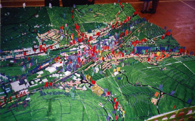
The Slaithwaite PFR exercise was co-ordinated for CVT by NIF and part funded by KMC. A 1:1,000 scale three dimensional model of a 2km2 area of the Slaithwaite village and valley was constructed by CVT and NIF with the help of local school children (see Figure 1). This was used as a focus for local discussion about planning issues within Slaithwaite. Local people were invited to register their views about particular issues by placing flags with written comments on to appropriate locations on the model. The results of this exercise were then collated by NIF with the potential to feed them back into the planning process via the Local Authority.
One of the main aims of CVT is to consult with local people to find out their views, and involve them in local decision making and actions. The main features of the method are:
With particular reference to Slaithwaite, which has problems and concerns in common with other villages in the area, it was decided that the village would be the first in the Colne Valley to have the opportunity to undertake the PFR exercise. Additional problems being faced ranged from the disruption the canal restoration would make coupled with more serious traffic problems. There were also many issues surrounding public buildings, with many of the old buildings in disrepair. With a diverse set of issues and views potentially being expressed by residents in the village the potential for conflict would appear to be inevitable. One of the advantages of the PFR method is that compromise and consensus become easier as all participants efforts become focused on the physical model. This allows practical non-threatening modes of interaction by being anonymous. The placement of a flag on the model expressing a view point has no attachment to an individual, unlike in a public meeting where people can attach a face to a point of view.
Figure 1: Part of the Slaithwaite PFR Model
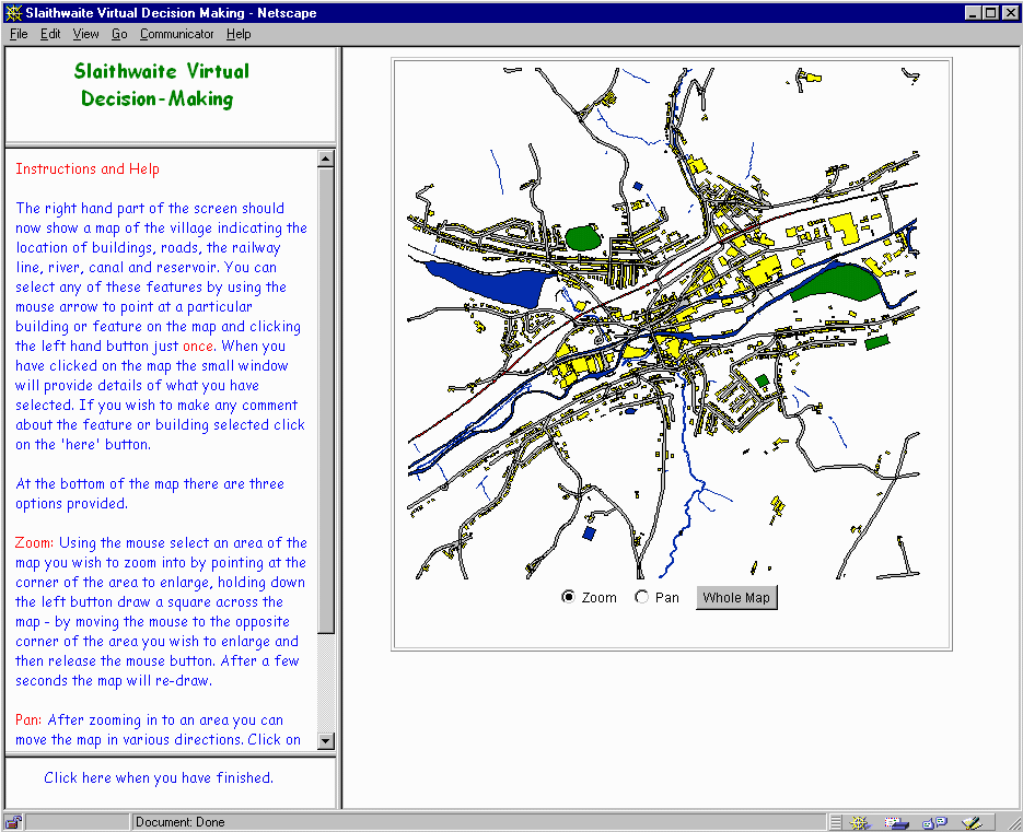
The PFR initiative provided the research project with an ideal opportunity to test out new methods of public participation by running a parallel exercise over the World Wide Web. Notwithstanding the current limited access in the UK the Slaithwaite PFR exercise provided the research project with an ideal opportunity to develop, pilot and live test a simple Virtual Decision Making Environment (VDME) that mirrored the functionality of the physical PFR model. The virtual version of the exercise was launched on the web along side the physical PFR model at a local village event organised and run by CVT. Using the same 2km2 area of land around Slaithwaite the project developed a virtual model of the village which allowed the local community to interact with a virtual digital map giving them relatively instant access to queries which they pose and the ensuing results. The Virtual Slaithwaite system is an on-line GIS facility and was arguably among the first such system available to the public which allowed a two-way flow of information. The design of the system revolves around a Java map application called GeoTools (Macgill and Turton, 1998) that allows the user to perform simple spatial query and attribute input operations (see Figure 2). Using this Java map applet, users can view a map of Slaithwaite, perform zoom and pan operations to assist in visualisation and navigation, ask such questions as "what is this building?" and "what is this road?" (spatial query) and then make suggestions about specific features identified from the map (attribute input). All user input is stored in the web access logs for future analysis and feedback into the planning process. In this manner a community database can be created, representing the range of views and feeling about planning issues in the locale.
The small window in the top left hand corner of the screen displays what has been selected and the 'Instructions and Help' window changes to a form which can be filled in with the comments and suggestions regarding the selected feature. When a feature is selected a free form text box allowing the user to type what ever they wish appears in the left -hand window which is then 'sent' to the system for future analysis (see Figure 2). All user input can be stored in the web access logs which is then used for future analysis and feedback into the planning process. In this manner a community database is created, representing the range of views and feeling about planning issues in the village. When the user has finished they exit the system and are provided with a series of questions asking them how they felt about using the system and they are given the opportunity to make any comments.
Figure 2: Virtual Slaithwaite
Public Participation and Understanding
Traditional methods of public participation at planning meetings quite often involves an atmosphere of confrontation. This can discourage participation by an often less vocal majority causing public meetings to be dominated by individuals who may have extreme views. These views may not necessarily represent the wider view of local people. Planning meetings often tend to take place in evenings at specific times that can limit the numbers of people who are able to attend. The restricted time and also the actual geographical location of public meetings can further restrict the possibility of widespread attendance. Physical access to such meetings can also cause problems for the disabled, the elderly and infirm as well as those who maybe deaf.
There are many advantages to a web based approach at local, regional and national public participation events. The meetings are neither restricted by geographical location nor time. Access to the information about the issues being discussed is available from any location that has web access. The information is also available at any time of the day thus avoiding the problems associated with holding meetings only in evenings. The concept of a "24/7", i.e. 24 hours a day, 7 days a week access opens up opportunities for more people to participate in public consultations. Essentially with a web based system the public is at the end of a telephone line that enables them to make comments and express their views in a relatively anonymous and non-confrontational manner compared with the traditional method of standing-up in front of a group of relative strangers.
A web-based system is unique in its ability to provide a 2-way flow of information from the public to the system and back again. In the Slaithwaite example the inputting of comments by the public directly into the system saves time and money. With the physical model comments made by the public have to be collated and put into a database by, in this instance, CVT which can take several weeks to compile and analyse. With the web based system this process is continually being updated as the public use the system and input their comments. The system offers a high degree of flexibility, buildings can be altered or updated with more relevant information throughout the public participation process. Several people commented on the 'Virtual Slaithwaite' system that a road and some buildings had been named incorrectly. This information allowed the system to be updated immediately by the operators.
In a traditional PFR setting using a physical model of the village the public are encouraged to place flags on places where they wish to express views and opinions. This places limitations on the amount of information that the public can put across in the form of the flags which are relatively small. The web-based system allows people to express more articulated views or comments about issues as opposed to the use of a flag placed on the physical model. NIF found the web based method useful and believe that there maybe potential to incorporate a stand-alone, i.e. non-web based system into their own PFR process. With the traditional method NIF representatives have to take the written proposals, which have been placed on the flags, off the model periodically and collate this information in a database for future analysis. With the computer model the public input their comments directly into the system thus bypassing the requirement of NIF to do this, saving them time, effort and inevitably money. Considering NIFs enthusiasm for a similar system, not necessarily web based, we are seeking additional funding to further this type of work and develop the research and development of such systems in similar settings. While a web based system may not be necessary for a small scale village sized study a similar process for a more geographically dispersed population could play an increasing role in future public participation processes. It should also be noted that these systems are seen as ways to enhance, not replace, current methods.
Widespread use of the Internet and the World Wide Web is still some time away although the speed at which business, government and to a certain extent the public have adapted to using the technology is arguably faster than any other technology preceding it. As computers become more widespread especially in schools and the workplace the ability of the general public to use and feel comfortable with computers and technology will increase. Computer software for drawing and manipulating map-based software has over the past decade become much easier to understand and operate. As the famous Chinese philosopher Confucius once wrote 'a picture is worth a 1,000 words' and can thus relay a lot of information quickly and understandably to a wide audience. The use of a map as the central theme of the web-based system should provide instant familiarity of the location in which the public participation process is taking place. Several pieces of research in the past have questioned the public's ability to understand a map that is essentially a 'birds-eye' view of a place. Many people do not instantly recognise a location when it is presented to them as an areal view although this did not seem to be a problem with our on-line system. One explanation for this is the ability of the user to click on a feature on the map and be interactively informed what that feature is such as a road, restaurant, community building etc. This capability in the system helps the user to familiarise themselves with the map. It is possible to provide a facility whereby the public type in their postcode or street name for example and the map zooms in and centres around their home or are of interest.
Using a dynamic map, i.e. one that is interactive and provides endless information about features on it, allows the user to elicit greater detail about issues and problems in hand. This type of information is impossible to provide on a traditional paper map and allows a much richer environment for the user to interact with. A feature which was not included in the Slaithwaite system but would have provided improved understanding for the public would have been visual images such as photographs or even video footage of parts of the village to improve the familiarity of locations within the village. For example, photographs or artists impressions of the new canal through the car park could have been provided allowing the public to gain a better understanding of how the new canal will look in the village centre. The noise from traffic along particular roads could also be incorporated into any future systems. Examples of this can be found in the work Schiffer (1995) with example of noises generated from airports.
Figure 3: On-Line Public Comments

As the Internet and more specifically the WWW develops and becomes a more widespread and accepted technology its use in public consultation exercises is likely to increase. The use of animation and 'real-world' images incorporated into such a system will breed familiarity and overcome some of the problems highlighted earlier in relation to map cognition. One encouraging aspect gleaned from this case study was the relative ease with which the people of Slaithwaite seemed to grasp the concept of using the WWW. This appears to go against some of the work done by others in the past on public interpretation of maps. One noticeable feature was the way parents and their children used the system. There were many cases where children would operate the mouse and use the key board while there parents and grandparents would direct them around the map getting them to click on particular features and tell them what to type in.
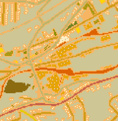
On the whole it appears that the public response to the system was positive, particularly with the ability to type in comments at great length, as opposed to being restricted to a short sentence. Figure 3 above shows the location on the map of public comments, represented as yellow dots. The red dot represents a comment made that has been selected and can be read on the left part of the screen. The ability to provide feedback and read other peoples' comments could potentially be used for conflict resolution or on-line debate and discussion about particular issues. Many comments were made regarding the reduction in the size of the car park as a result of the canal being re-opened that can be identified on the comments map by the clustering of yellow dots in this area.
Who Benefits From A Public Participation GIS?
The potential numbers of people who can benefit from effective public participation make such processes worthwhile as they can benefit whole communities and provide the necessary input into difficult problems. Too often in the past the public have been seen as getting in the way of implementing and driving forward policy. It has often been the case though that a lack of public consultation has led to future problems within communities when they are ignored and not asked their view. Exercises such as Planning for Real® in the traditional sense and also complemented by the type of system developed for Slaithwaite can provide a community with a voice with which to express their opinions and ideas about the places where they live and work. Community groups and organisations such as Colne Valley Trust, other non-Governmental organisations, pressure groups and the Local Authorities themselves can all benefit from the use of effective public participation techniques.
Collaborative public consultation in local decision making and planning whether relating to conservation, development or conflict resolution can take place through web based systems allowing increased public use. It is envisaged over the next 5 years or so that due to the Webs ability to provide information at any time and without any geographical constraint, the 24/7 concept, greater participation by all communities is possible. Since the PFR day in June 1998 several local authorities throughout the UK have increased the amount of information they provide on the web. While none have the interactive two-way capabilities of the system we have developed many of them are actively investigating the potential of undertaking similar kinds of web based public participation processes. For example Bradford Metropolitan Council are investigating the feasibility of providing web access to some of their internal GIS data. As the web continues to increase in popularity the type of system which has been tested in Slaithwaite is likely to be applied in similar situations in other parts of the country hopefully allowing a more transparent process in local environmental decision making. In the case of a local authority planning documents relating to public inquires and consultations on revisions and updates to development plans could be carried out across the WWW at all stages of the process. This could range from the initial public consultation, through information gathering from the public and building cases for and against particular policies and/or developments etc. Several local authorities (see for example the London Borough of Hackney) have started to post their weekly planning applications with architectural drawings and designs on the WWW.
Problems Encountered
One problem identified relating to the users of the physical model was the noticeable lack of generating considerable interest in the late teens to late twenties age groups. Attending public meetings and expressing an opinion is not viewed as a particularly fashionable way to spend your evenings by this age group. The Internet and the World Wide Web could help to popularise the concept of public participation through several channels. Whether access is obtained through the home or through a cyber-caf� the anonymity of participation maybe the key to increasing the numbers of younger people participating in local democracy. The modern and fashionable nature of the web also has the potential to increase participation within this age group.
Several issues still need resolving around the following themes:
- Copyright;
- Intellectual Property Rights;
- legislative context of planning law - is there enough time in the legal process to undertake an on-line exercise to compliment current methods?
While the Slaithwaite case study worked extremely well the testing of further on-line public participation systems is urgently required in both similar and different scales of setting. This is partly being realised in the wider research project with two further case studies at the regional and national scales investigating new woodland planting and nuclear waste disposal respectively. The levels of public involvement, across different spatial scales in combination with a series of single and multi-issue problems, needs to be investigated. This will contribute to an improvement in the understanding the public has with regards particular planning issues and decision-making problems.
There are several constraints acting against the widespread development of PPGIS, particularly within the realm of public services and local government. While the technical problems associated with developing such systems are lessening, the legal and resources constraints maybe the downfall of successful PPGIS projects, particularly in a local democratic process. The main stumbling block centres around the legal and copyright issues of publishing Ordnance Survey map data over the WWW. From one aspect the Ordnance Survey see the Web as a useful tool for distributing their data to clients (Ordnance Survey, 1997), but the costs of using their data (Ordnance Survey, 1999) within a PPGIS context may well outweigh the benefits it would generate. The current proposal charges an annual licence fee together with costs linked to the number of 'hits' received on a map server. This has the potential to put the costs of serving a PPGIS beyond the budget of any local authority on-line public participation exercise. Hopefully some of these issues can be resolved through technical means.
It appears that one of the main worries of the OS is that data served over the Web could be extracted and manipulated in a proprietary GIS package, circumventing the purchasing and copyright costs of buying map data directly from them. Figure 4 below represents the results gained from taking a screen shot of the Slaithwaite web site, saving it as a tiff file and carrying out the imagegrid command in Arc/Info. Clearly the quality of this data as a representation of the village is far inferior to any paper map or Land-Line® data. The benefits of attempting to take the image from the web site and transporting it into a GIS package are very few. Methods of serving the data across the web in a format which would not allow re-manipulation of the data may be one way of solving this problem. Essentially the OS map which appears on the screen from the web site is a bitmap. The quality of this when printed is not particularly high and the potential for transferring this into a GIS package is, again, limited. Furthermore, the general public to whom a Public Participation GIS (PPGIS) is aimed are unlikely to wish to transfer a map to their own GIS package - assuming they realise they are actually using a GIS!
Figure 4: Arc/Info Grid of Village Centre
Conclusions
The research outlined here is on-going and several important issues concerning public access to the WWW are possibly more important than the actual ability to develop systems which the public can understand and use. It needs to be recognised that access to the WWW is still relatively limited in the UK although the potential for increasing this appears to becoming a reality. If planning authorities and other decision making organisations wish to see an increase in public participation they have to realise the need to provide public access points in libraries, community centres and other public areas and buildings which the general public can easily access (CCTA Government Information Service, 1998).
Considering that most people's concerns regarding their surroundings involve spatial entities (mental maps, landmarks etc.) the use of GIS on the WWW has great potential for popular involvement. Questions have been raised about peoples understanding of maps. Many studies have investigated the ways people perceive and relate to information displayed on a map and how maps can interpret and display information in different ways (Keates, 1996, Wood, 1993). Evidence from this case study has suggested that this was not a too greater problem for people using the system under investigation here. It is suggested that in particular planning problems and policy formulation processes participatory on-line systems will become a useful means of informing the public and to allow access to data and planning tools such as on-line GIS as an additional means of public participation in the planning process. These will provide mechanisms for the exploration, experimentation and formulation of decision alternatives by the public in future planning processes and have the potential to move the public further up the participatory ladder.
While the 'Virtual Slaithwaite' system has worked relatively well further work in several areas is required before this participatory method could be adopted as a robust technique to compliment current public participation processes. Considering this system was one of the first of its kind allowing a two way flow of information and data between the public or 'user' and the 'client' the case study has provided very positive signs that their is future potential for this type of on-line web based participatory system. The concept of a two-way interaction between as user and client opens up many possibilities for participatory techniques. In this sense while the user may range from individual members of the public to groups with common concerns, the client side of the system comes in many guises. In the Virtual Slaithwaite system the client represented CVT as the initiator of the whole PFR process. In other cases the client could be the local authority who may decide to use the web for other participatory processes such as the progression of an authority wide planning document or a local based initiative. The range of possibilities for carrying out this type of participatory technique is endless.
It is clear that many more case studies and research and development work is required to investigate the use of more and different types of data. Case studies relating to different issues and different spatial scales are also required. Further work involving different sectors of the community is also required to develop more of an understanding regarding the public acceptance and understanding of web based participatory techniques. While the Slaithwaite case study appeared to run relatively smoothly more work needs to be undertaken with a range of age groups in the population to discover their ability and understanding of IT.
Public access to the Internet is still relatively low at the moment. All the indications suggest that levels of access are improving as many Internet Service Providers are offering free access with only local telephone calls to be paid for. While this is encouraging it hides the fact that the types of people going on-line are dominated by middle class educated people. To avoid other sectors of society from being excluded innovative means of engaging these people, such as the unemployed, are required. Public access points in libraries, community centres and other public buildings should be encouraged. Where public involvement in particular public participation initiatives is required systems can be set up which allow access only to information on the specified issue. This resolves the problem of providing unlimited WWW access that encourages people to get distracted by other web sites containing inappropriate information. Many local authorities have public information systems and kiosks. These can be adapted to provide facilities relating to specific decision making questions and problems.
Conventional GIS contain various map data types: e.g. roads, rivers, building plan outlines, heights, utility networks etc. All of these data have very crisp and well defined boundaries. A public GIS needs to go several steps further to contain additional data more appropriate to the needs of the general population. User defined areas need to be accounted for which can help to provide and elicit vital information from the public not necessarily identifiable through a conventional map. The facility to allow the public to input their own data is an essential part of a PPGIS whether it be their own sketched polygons, special interest areas or communities of people who associate themselves with particular labels. Many aspects of life are missed by conventional map and statistical data layers and facilities for incorporating this type of missing information is essential. The representation of conventional map data from a technical point of view is becoming increasingly easier as more 'off the shelf' packages become available such as ESRI's ArcView Internet Map Server and MapObjects Internet Map Server. The real challenge, and an area for future research, is how to elicit, represent and handle user defined information from a GIS perspective.
At present there is very little evidence on how local authorities view and may react to the possibility of on-line public participation systems. While nearly all local authorities have web sites the levels of interaction and participatory tools available within them are extremely limited at present. Over the next 5 years or so the use of the WWW by local authorities will inevitably increase and its potential for carrying out public participation processes in all areas or local authority work is boundless. Central Government is proposing that "Within five years, a quarter of dealings with Government can be done by a member of the public electronically through their telephone, TV or computer" (Cabinet Office, 1997). From the evidence received so far it appears that the World Wide Web offers a great opportunity to increase public involvement in local decision making and can help to make such events more popular.
Footnote:
The Neighbourhood Initiatives Foundation (NIF) is a National Charity, founded in 1988, with the main aim of maximising the participation of local people in decisions that affect their neighbourhoods and their quality of life. The founding director, Dr Tony Gibson, devised "Planning For Real" ® in the 1970s as a technique that is employed by the NIF fieldwork team. NIF has continued to develop and adapt this primary tool to meet both local and strategic consultation needs and as an essential process in community development programmes. NIF fieldworkers usually facilitate the process using large 3D scale models of the local area.
Acknowledgement
This research is being undertaken in the School of Geography at the University of Leeds and is funded by the Economic and Social Research Council's Virtual Society? Programme from November 1997 to October 1999.
References
Carver, S. (1999) Developing web-based GIS/MCE: improving access to data and spatial decision-support tools. in J-C.Thill (ed) Multi-criteria decision-making and analysis: a geographic information sciences approach. Ashgate.
Central IT Unit (1997) Towards Information Age Government: Electronic Service Delivery of government services, Cabinet Office, [on-line] http://www.citu.gov.uk/25percentoutline.htm, Accessed 13 April 1999.
Brent Council (1998) LA 21 On-line Consultation, [on-line] http://www2.brent.gov.uk/recycle.nsf, Accessed 13 April 1999.
CCTA Government Information Service (1998) 'Open for Learning, Open for Business' [on-line] http://www.dfee.gov.uk/grid/challenge/index.htm, Accessed 13 April 1999.
County Wicklow (1998) Planning Applications in County Wicklow - Interactive Mapping System, [on-line] http://www.wicklow.ie/planning/, Accessed 13 April 1999.
Devon County Council (1998) Devon County Structure Plan First Review - Deposit Version [on-line] http://www.devon-cc.gov.uk/structur/, Accessed 13 April 1999.
Keates, J.S. (1996) Understanding Maps. Addison Wesley Longman Ltd. Second Edition.
Macgill, J. and Turton, I. (1998) The Geotools Package, School of Geography, University of Leeds, UK, [on-line] http://www.ccg.leeds.ac.uk/geotools.html, Accessed 13 April 1999
Ordnance Survey (1997) Developments for the World Wide Web (WWW), Information paper 13/1997. Southampton: Ordnance Survey.
Ordnance Survey (1999) A new pricing policy for mapping on the Internet, Information Paper 1/1999 Version 2. Southampton: Ordnance Survey.
Shiffer, M. (1995) Interactive Multimedia Planning Support: Moving from Stand Alone Systems to the World Wide Web. Environment and Planning B: Planning and Design, Vol.22, pp.649-664.
United Nations (1992) Conference on Environment and Development "Earth Summit", Rio de Janeiro, Brazil, June.
Wood, D. (1993) The Power of Maps. London: Routledge.
Relevant Web Pages:
| Colne Valley Trust: | http://www.digitalhighway.co.uk/colne-valley/ |
| ESRC Virtual Society? Programme: | http://www.brunel.ac.uk/research/virtsoc/ |
| Geotools: | http://www.ccg.leeds.ac.uk/geotools.html |
| Kirklees Metropolitan Council: | http://www.kirkleesmc.gov.uk/ |
| London Borough of Hackney: | http://www.planning.hackney.gov.uk/ |
| VD-MiSP Project: | http://www.ccg.leeds.ac.uk/vdmisp/ |
| Virtual Slaithwaite: | http://www.ccg.leeds.ac.uk/slaithwaite/ |
Contact Details:
Richard Kingston
School of Geography
University of Leeds
LS2 9JT
Tel: 0113-233-3342
Fax: 0113-233-3308
E-mail: richard@geog.leeds.ac.uk