A fuzzy modelling approach to wild land mapping in Scotland
Steffen Fritz, Linda See and Steve Carver
School of Geography, University of Leeds, Leeds, LS2 9JT, United Kingdom
E-mail: s.carver@geog.leeds.ac.uk
Abstract
This paper outlines a methodology for wild land mapping. An Internet questionnaire has been designed to collect perceptual information on how different man-made features affect an individual's overall perception of wild land. A fuzzy logic modelling framework is proposed to combine the different wilderness indicators to produce a fuzzy wild land map. This methodology is demonstrated on a small area in the Cairngorm Mountains of Scotland but has the potential to be extended to other regions in Scotland and, with modifications, to other areas in Europe.
1. Introduction
The use of GIS for wilderness mapping is a recent development, but several attempts have already been made that cover a range of different areas across the globe (Lesslie, 1993, 1995; Henry and Husby, 1994; Kliskey and Kearsley 1993, 1994; Carver 1996). Methodologies range from the mechanistic and rigorous approach adopted by the Australian Heritage Commission (1988), which used deterministic, yet arbitrary parameters, to the approach of Kliskey and Kearsley (1993), which accounts for the subjective nature of wilderness using Stankey's wilderness purism scale (Stankey, 1977). However, there are drawbacks to the way in which Kliskey and Kearsley (1993) have translated the perceived levels of wilderness to the spatial domain. Moreover, none of these methodologies are directly applicable to Scotland. Here the term 'wild land' is proposed as a better representation of a landscape that has been dramatically altered due to its long history of settlement and rural land use (Aitken, 1977). In terms of biophysical naturalness, wild land has ceased to exist in nearly all areas of Scotland. Nonetheless, people still value the land according to factors such as solitude, remoteness and the absence of human artefacts and as such perceive it as wild. However not all factors can be measured easily in a quantitative sense (e.g. solitude is highly dependent on the weather and personal ideals). Nevertheless, there are two main factors having a strong influence on wild land perception in Scotland that can be quantified. One factor is closely linked to the idea of the 'long walk in' and termed here as 'remoteness from mechanised access'. It can be measured as the minimum time it takes a walker to reach a particular destination from any origin (usually a road or car park). A second factor strongly influencing wild land perception is the impact of certain man made features such as roads, hill roads, pylons, hydroelectric power plants etc. The presence of such features can detract from a 'wild land experience', particularly when the features are visible within the landscape.
This paper describes an approach to building a spatial mapping tool for wild land areas that captures qualitative perceptions of the factors affecting wild land quality. The methodology uses an Internet questionnaire designed specifically to collect softer, perceptual information such as naturalness (forest and land cover) and artifactualism that are important wild land indicators. This information is then translated to the spatial domain through a fuzzy logic modelling framework that is used to combine these perceptions to produce a fuzzy wild land map. The method has been applied to the South West area of the Cairngorms.
2. Methods of wilderness mapping
Several authors (Lesslie, 1985; Hendee, 1990; Countryside Commission, 1994; Carver, 1996) agree that there is no generally accepted definition of wilderness or wild land. A perceptual or sociological definition of wilderness can be found in Nash (1982). He defines wilderness from a personal perspective:
"There is no specific material thing that is wilderness. The term designates a quality that produces a certain mood or feeling in a given individual and, as a consequence, may be assigned by the person to a specific place. Wilderness, in short, is so heavily freighted with meaning of a personal, symbolic, and changing kind as to resist easy definition". (Nash, 1982, p.5)
Nash therefore defines wilderness as what people perceive it to be. Due to the fact that the perception of wilderness quality by recreationalists differs widely among individuals and is influenced by a variety of personal factors, the establishment of a wilderness or wild land threshold is arbitrary. It is a definite advantage, therefore, to identify wilderness areas in a relative way either as a continuum or using fuzzy concepts.
Lesslie et al. (1988) define wilderness as undeveloped land which is relatively remote, and relatively undisturbed by the process and influence of settled people. Neither remoteness nor primitiveness can be assessed by a single wilderness quality indicator. Remoteness can be described as a proximity function to settled land and settled people. Primitiveness is a more complex attribute since it has both a subjective and an objective component, but could possibly be described as biophysical and apparent disturbance. Therefore 4 wilderness indicators can be defined.
By summing together the four wilderness indicator values assigned to each grid point, a simple estimation of wilderness quality can be obtained, as shown in Figure 1. However, the simple addition of indicators in this manner assumes that they contribute equally to total wilderness quality. The indicators are not necessarily comparable in a quantitative sense and computerisation of the method allows alterations to be made. One type of alteration would be to give different weights to the different wilderness indicators. Each of the wilderness indicators can be displayed individually and compared with the final wilderness map. This creates the opportunity to locate those features which influence wilderness quality (Lesslie et al., 1988; Lesslie and Maslen, 1995). This method has been used to map Australia at the national level. However, this approach has been criticised for being too mechanistic and not taken into account the perceptual nature of wilderness (Bradbury, 1996; Kliskey and Kearsley, 1994). Nevertheless it is seen as an effective and efficient way of deriving wilderness quality.
In a different approach Kliskey and Kearsley (1993) mapped different peoples' perceptions of wilderness. Kliskey and Kearsley’s (1993) study is based upon the premise that the concept of ‘multiple perceptions of wilderness’ is valuable as a theoretical notion. The theoretical background of this approach is shown in Figure 2. The method is an approach to wilderness mapping, where the concept of wilderness comes close to the definition of Nash (1982). It concentrates on the management of a national park and maps wilderness from the viewpoint of a backcountry user. One disadvantage of their approach is that it is area specific, i.e., the wilderness mapping study, which was carried out in the Nelsons National Park in New Zealand, can only be applied locally since the questionnaire has been specifically designed for that area.
Kliskey and Kearsley (1993) also determined that the spatial criteria for determining the influences of man made features was made on an arbitrary basis. Wilderness was assessed for a national park area in the north of South Island, New Zealand. This ‘wilderness’ perception survey looks at measuring four properties: artifactualism (absence of human impact); remoteness; naturalness (aspect of forest and vegetation); and solitude. Four backcountry user groups were categorised with the use of a wilderness purism scale. This scale has been used to provide a mechanism that accommodates the variation of user definitions of wilderness (Stankey, 1973). Backcountry users were asked about their view towards desirability of various activities and experiential items in what they considered to be a wilderness setting. A value from 1 to 5 was assigned to each response (from strongly desirable to strongly undesirable) and each group of the wilderness purism scale had a range of scores (e.g. non purist 16-45). Contingency table analysis of purism groups and desirability of items in what is perceived as wilderness were used, supporting the use of these indicators for differentiating and determining variations in perception levels. The results were then translated into a spatial concept according to remoteness (e.g. roads), aritfactualism (mines, lighthouses, etc.) solitude and naturalness. The maps produced reveal that differing user groups have entirely different perceptions of wilderness (Kliskey and Kearsley, 1993; Kliskey, 1994). The work can then be used in a management framework for the zoning of the ‘wilderness resource’.
The method proposed here captures information in a similar way to Kliskey and Kearsley (1993), but with an Internet questionnaire. However, the difference is that people are directly asked to evaluate the spatial impact of a man made artefact and the impact of coniferous plantations and arable land. Additionally they can differentiate between features that are visible and those that are not. Instead of using simple buffers around the features (Kearsley, 1993), factors influencing wild land are combined within a fuzzy framework. This enables people to establish their individual criteria and produce their own wild land map. The following study captures information on naturalness (forest and land cover) and artifactualism. They can be considered as important wild land indicators, together with the wild land indicator ‘remoteness from mechanised access’.
3. The Internet questionnaire
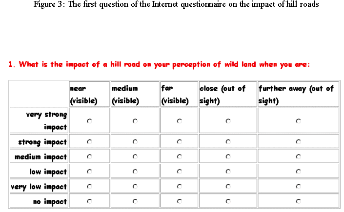
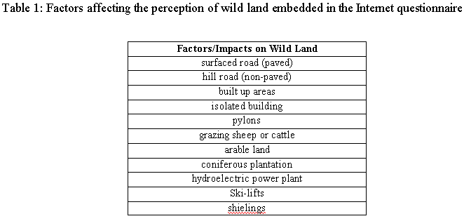
A questionnaire was specifically designed to gather information about the perceived impact of various factors on wild land quality. The questionnaire was posted on the Internet to promote wider accessibility and to allow users to view and alter the resulting wild land maps based on their perceptions. Participants will also be able to view a composite map that is based on an average of all the participants' responses in a particular category in a future version. The Internet questionnaire consists of three parts. In part one the user is requested to enter personal information whilst in part two there are some general questions about hiking in Scotland and in the area covered by the questionnaire in particular. Information from these two parts will be used to classify the participants into different behavioural groups. Part three contains the main questions regarding the impact of certain features on the participant's perception of wild land. The respondents are first required to define a set of fuzzy spatial concepts in metres or miles, which include being near to, a moderate distance away from and far from visible features as well as the concepts of close and far away from features not visible, but which can still have an impact on the perception of wild land. Eleven questions follow which are all in the same style. The participant is required to think about what the impact on wild land is ranging from no impact to a very strong impact based on being near, a moderate distance away and far to a visible feature or close and further away from features that are out of sight. Questions referring to the factor 'hill road' are provided in Figure 3 and all the factors are displayed in Table 1 The final question asks whether the participant thinks there are factors additional to the ones listed in questions 1 to 11 which may affect their perception of wild land and which can be used to improve the questionnaire in the future. The questionnaire can be found at the following address:
http://www.ccg.leeds.ac.uk/steffen/questionnaire1.html
4. A fuzzy logic modelling approach to wild land mapping
Fuzzy logic is one of several new alternative approaches to modelling that has emerged from the fields of Artificial Intelligence and process-based engineering. Originally formulated by Zadeh (1965), fuzzy logic replaces the crisp and arbitrary boundaries with a continuum, thereby allowing the uncertainty associated with human perception and individual concept definition to be captured. For this reason, fuzzy logic is particularly well suited to wild land mapping because it enables different factors influencing the perception of wild land to be integrated into a fuzzy wild land map, analogous to the way in which our brains might handle this information in a decision-making process. It also allows one to map different degrees of wild land quality, thereby eliminating the crisp boundary between wild and non-wild land. Moreover, this approach explicitly considers the spatial component by asking people to define their concept of distance and the subsequent impact of certain man made features on their personal definition of wild land.
4.1 Visibility and distance analysis
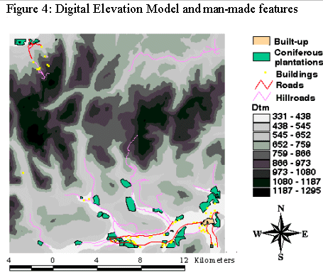
A visibility map on the South West area in the Cairngorm Mountains in Scotland was produced using the ARC/INFO GRID module at a 50m resolution for five factors on the questionnaire including paved roads, hill roads, built-up areas, isolated buildings and coniferous plantations. A visibility analysis of the Digital Terrain Model (EDX data) was undertaken for each individual man-made feature. The distance of the closest visible feature of each factor was recorded. These factors were extracted from the LCS88 land cover map (MLURI). Additionally, the closest Euclidean distance was calculated for each factor in order to acquire a data set for those areas where a feature is not visible, but which still has a potential influence on wild land perception.Figure 4 shows a map of the DTM with the features used for this study. In the future, the remaining factors on the questionnaire will be taken into account including: hydroelectric power schemes, pylons, shielings, grazing (cattle, sheep), ski lifts and agricultural land.
4.2 A fuzzy logic model for mapping wild land
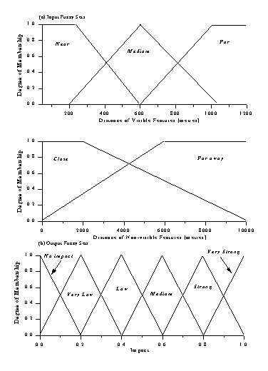
The distances specified by the respondent were used to construct fuzzy sets for defining the concepts near, medium and far for visible features and close and far away for non-visible features. The user-defined distances were assumed to have membership values of 1.0 and were constructed to completely overlap neighbouring sets. The output sets for wild land quality, which range from a very strong impact to no impact were evenly spread across a continuum of 0 to 1. Example fuzzy sets are provided in Figure 5 assuming values of 200m, 500m, 1km, 2km and 6km for the five distances.
Each question regarding the impact of a single factor produces a set of fuzzy rules. Each rule, which might be one of several possible answers input by a respondent, takes the form:
If you are near to a surfaced road
Then this has a very strong impact on wild land quality.
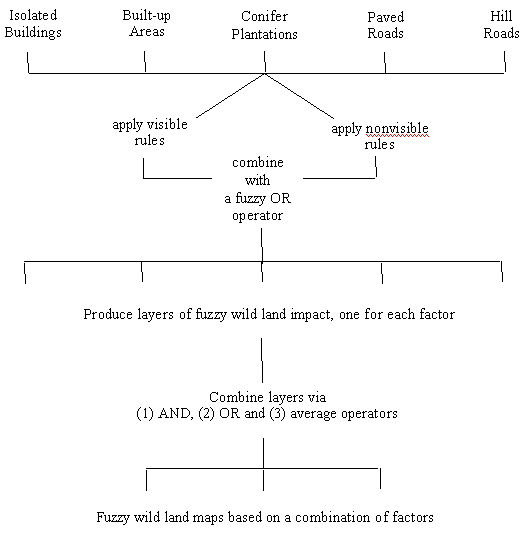
Each question can yield a maximum of 12 rules which link a distance to one of six fuzzy sets for the impact on wild land quality; 6 of the rules correspond to visible features while the other 6 cover non-visible features. Figure 6 provides a methodological outline of the procedure for processing the rules for each individual layer and then combining the layers to produce an integrated fuzzy wild land map. For each grid cell, the visible and non-visible distances to a given feature are used to determine the membership values in each of the distance fuzzy sets. A classical fuzzy OR operator (Zadeh, 1965) which involves taking the maximum membership is then used to combine the rules from the visible and non-visible rule bases. This means that the impact on wild land quality from a given factor will be determined by the highest value regardless of visibility. The fuzzy model is applied to each layer producing fuzzy wild land maps based on only one factor. To combine them, different Boolean and fuzzy decision-making operators can be used to integrate the layers into a single map. These operators represent various decision-making modes, for example, the fuzzy OR or maximum creates a map based on the factor that is the most important while the fuzzy AND or minimum represents a risk-adverse approach. For wild land the fuzzy AND is not appropriate but can be replaced an additive AND in which the individual layers are summed to produce a resulting value for wild land quality that combines all the factors. Another approach for taking all the factors into account is to average them producing a more balanced result. In this paper, only the fuzzy OR has been applied to combine the layers.
4.3 Sample results - Boolean vs Fuzzy logic
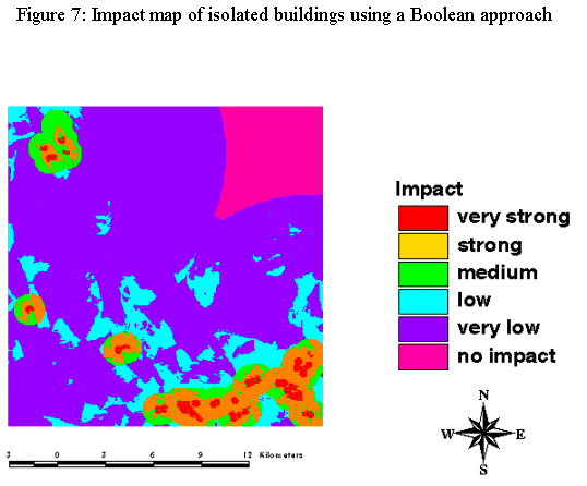
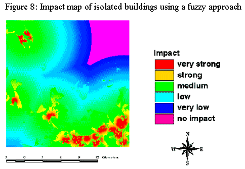
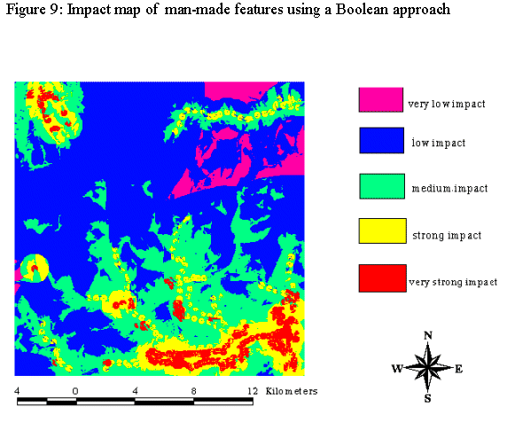
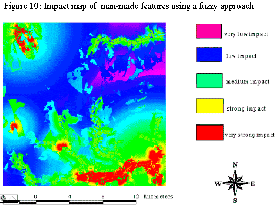
In order to be able to illustrate the differences between a fuzzy logic and a Boolean approach, two different maps were produced for each factor (impact due to the presence of hillroads, built-up areas, etc.). The distances defined by a respondent and their answers to the questionnaire were translated into the spatial domain. For illustration purposes, the factor 'impact of isolated buildings on wild land' is displayed here. Figure 7 shows the impact of isolated buildings on wild land taking into account the answer of one respondent to the questionnaire using a Boolean approach. Figure 8 shows the same map with a fuzzy approach. In Figure 9 all the factor maps created with the Boolean approach are combined by using an OR operator. In Figure 10 the fuzzy factor maps are combined with the fuzzy OR operator. The results show that the fuzzy approach is more plausible and reflects the perceived impact of man made features much better. The crisp boundaries disappear and are replaced by a gradual decrease in wild land impact as distance away from each feature increases. This better reflects the way in which a person might possibly perceive impacts on wild land. An abrupt change of values can only be noticed on the border between visible and non visible areas but further improvements to the methodology will smooth out this boundary in the future.
5. Current problems, improvements and further research
Although the fuzzy wild land maps appeared to produce a better result than the method used by Kliskey and Kearsley (1993), there are still some unresolved problems with this approach. For example, visibility analysis is a very computationally intensive process. Therefore this method may require considerable computational time if it were to be applied to larger areas and if more factors were taken into account. However, the analysis only needs to be performed once. Another drawback is related to linear features. For example, the visibility to the closest road has been recorded, but the length of that feature is not taken into account. The use of the OR operator to combine the maps is also problematic since it takes the strongest individual impact as the overall result and the combined impact of other features is therefore not taken into account. However, this can be overcome in the future by using different operators such as a weighted average that falls in between the two AND/OR extremes or other variations of the Order Weighted Averaging operators (Yager, 1998) which can be customised for the wild land perceptual decision making process.
Further improvements include: incorporating the second important wild land indicator ‘remoteness from mechanised access’, also referred to as 'the long walk in', and adding a mapping tool onto the Internet questionnaire so that respondents can view their perception of wild land based on any combination of factors. Users will be able to change their definitions and answers to produce a map that better characterises their perceived idea of wild land quality. It will also be possible to generate an average wild land map based on all questionnaire respondents for a given behavioural group so that individuals can contrast their perception within a wider population. Photographs showing different distances to each of the features might also be incorporated to aid in defining personal distance definitions in the future.
6. Conclusions
A methodology was presented for the creation of wild land maps based on the answers from an Internet questionnaire, which was designed to collect perceptual information on how different man-made features affect an individual's overall perception of wild land. The questionnaire appears to be a useful way for collecting soft information regarding the perceived impact of man-made features on wild land. A fuzzy logic modelling framework was used to create fuzzy wild land maps from individual factors and to combine the layers into an integrated fuzzy wild land map for a small area in the Cairngorm Mountains of Scotland. The fuzzy wild land maps produced a better and more plausible result than using pure Boolean operators. The methodology can also be extended to incorporate a large range of factors to produce an fuzzy wild land maps for individuals as well as an average that takes into account the answers of all respondents to the questionnaire or of a certain behavioural group.
Furthermore it has been shown that ‘wild land’ is not easy to map and it can only be done to a certain degree using measurable indicators. However, it is becoming increasingly important to try and quantify the less tangible resources such as ‘wild land’. For example, in a public enquiry a stronger case may be made against the construction of a hydroelectric power scheme if quantitative data is available to demonstrate the more non-quantitative points of objection such as the argument that the wild land character of a vast area may be spoilt. People arguing for a certain case feel much more confident when they can show a map of the size of the area that will be spoiled and to what degree it would influence the ‘wild land’ perception of the people. Additionally, areas with wild land characteristics can only be objectively compared, when quantified. This approach allows the ‘use’ of an area in an optimal way and to provide an opportunity for satisfactory ‘wild land experience’, while also maintaining the natural ecological processes of an area in a relatively undisturbed state.
Acknowledgements
The authors gratefully acknowledge the help of the School of Geography, University of Leeds in funding this research.
References
Aitken, Robert (1977) Wilderness Areas In Scotland, unpublished Ph.D. Thesis, University of Aberdeen.
Carver, S (1996) Wilderness Britain? Using GIS and Multi-Criteria Evaluation Techniques to Map the Wilderness Continuum, Working Paper 96/16, School of Geography, Leeds
Henry, D. and Husby, E. (1994) Wilderness Quality Mapping in the Euro-Arctic Barents Region: A potential Management Tool, from
http://www.esri.com/recourses/userconf/proc95/to150/p113.html
Kliskey, A.D. and Kearsley, G.W. 1993. Mapping multiple perceptions of wilderness in southern New Zealand, Applied Geography, v.13, 203-223.
Kliskey, A.D. 1994. A comparative analysis of approaches to wilderness perception mapping, Journal of Environmental Management, v.41, 199-236.
Lesslie, R. G. and Taylor, S. G. (1985) The Wilderness Continuum Concept and its Implication for Australian Wilderness Preservation Policy, Biological Conservation, 32, 309 - 333
Lesslie, R. G., Mackey, B.G. and Preece, K. M. (1988) A computer based method of Wilderness Evaluation, Environmental Conservation, Environmental Conservation, 15, 3, 225 - 232
Lesslie, R., and Maslen, M. (1995) National Wilderness Inventory Handbook of Procedures, Content and Usage (Second Edition), Commonwealth Government Printer, Canberra
Nash, R. (1982) Wilderness and the American Mind, Third Edition, Yale University Press, London
Stankey, G.H. (1977) Some social aspects for outdoor recreation planning, Outdoor recreation: advantages in application of economics, US Department of Agriculture Forest Service, Gen. Tech. Rep, WOO, 2.
Yager, R.R. 1998. Including importances in OWA aggregations using fuzzy systems modeling. IEEE Transactions on Fuzzy Systems, 6, 286-294.
Zadeh, L.A. 1965. Fuzzy sets, Information and Control, 8, 338-353.