Andrew Evans,
Richard Kingston,
Steve Carver,
Ian Turton
Centre for Computational Geography,
School of Geography,
University of Leeds,
Leeds, West Yorkshire, LS2 9JT, Britain.
Contact: aevans@geog.leeds.ac.uk
Even now, most online GIS are used for information provision, rather than participation (examples are provided in the Appendix). This reflects the youth of the web medium. The aim of most government agencies and non-governmental organisations has initially been to provide the public access to large quantities of pre-existing information. There is also a well justified fear that the web provides an unrepresentative sample of the population, excluding important sections of society, and that even for those who are online, there is no standard mechanism to verify their identity. Aside from these problems, there is also a lack of commercial impetus at present for web-based spatial representations that can be altered, have arbitrary information added to them, and be submitted to form a group consensus. This should be contrasted with the commercial impetus behind traditional database use on the web and even the commercial provision of simple map based information over the web with products such as ESRI's Internet Map Servers and Autodesk's MapGuide software.
http://www.ccg.leeds.ac.uk/slaithwaite/
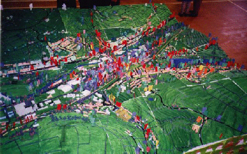
The village of Slaithwaite, in the West Yorkshire District of Kirklees was used as a test-bed for public participation "Planning for Real" (PfR) initiatives in the area. PfR was developed and patented by the Neighbourhood Initiatives Foundation (NIF), and involves the local community building a three dimensional model of the area, into which local people stick flags of various colours. Written on each flag are their ideas for places they put them. The colours represent different classes of problems such as "Health" or "Crime". In this instance, the map was built by local schoolchildren at a 1:1000 scale (Figure 1), and the event "Shaping Slaithwaite: a bit of a do" took place on the day of the village fair, making it well attended by a broad range of the community. The exercise was planned as the highlight of the day with entertainment from the local brass band and choir, and information on other local projects. The event was co-ordinated by NIF and the information fed back to the local community and government body (CVT, 1999a/b).
Figure 1: PfR three dimensional map (3.3m by 3.3m)
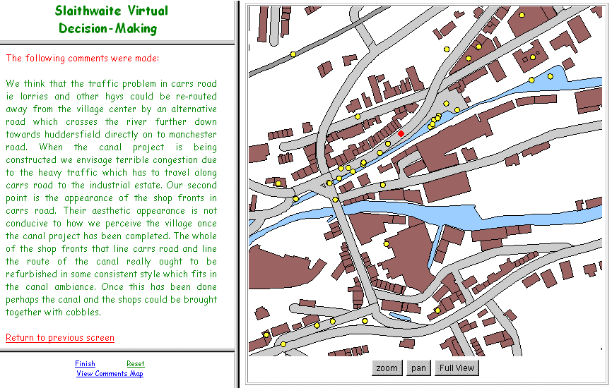
In parallel with this event, a web-based version of the map was developed (Figure 2), which was arguably among the first such system available to the public that allowed a two-way flow of spatially referenced information. To facilitate access to the web application the authors took eight PCs running the site to the "Shaping Slaithwaite" event. The application provided a vector map of the area, which could be zoomed, panned, and on which features could be queried. If the user felt a particular feature, or area of open ground, should be developed they could call up a form that allowed them to enter their suggestions. Demographic information and information on the users' feelings about the system were also collected. The application was implemented using the vector classes from "Geotools", a Java class package for the display and querying of ESRI shapefiles. The user responses were handled using perl server-side scripts and html forms. Unlike the PfR map, it was decided not to allow users to view other people's comments to encourage imaginative responses. However, at the end of the consultation period the system was adjusted to allow the public to query the map for everyone's comments (Figure 3). These comments were fed into the PfR process.
Figure 2: "Shaping Slaithwaite" web site (click on image for example interface)
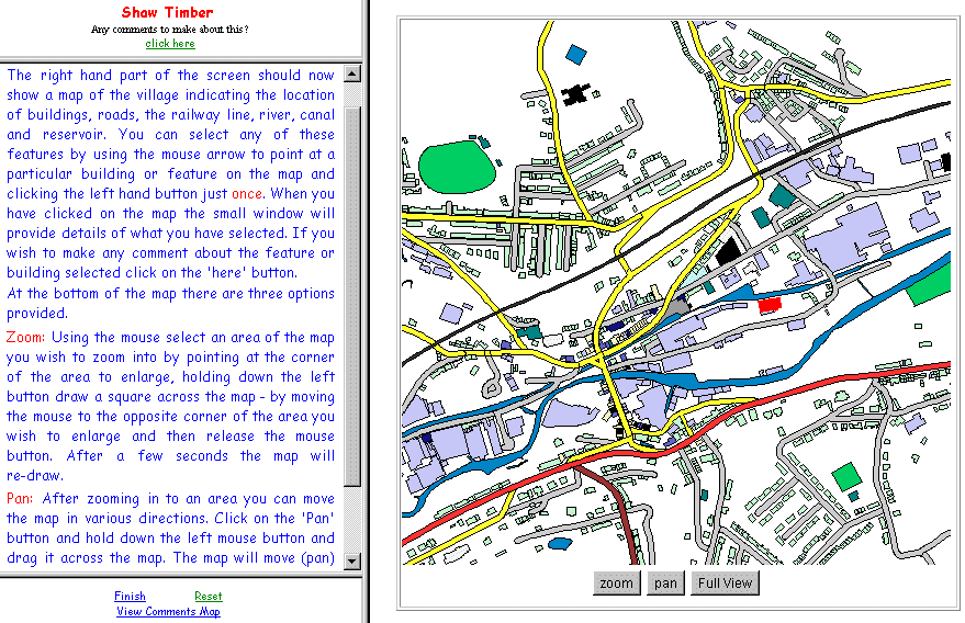
Figure 3: "Shaping Slaithwaite" comments (click on image for example comment)
http://www.ccg.leeds.ac.uk/dales/
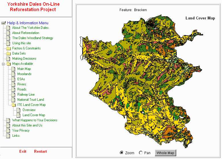
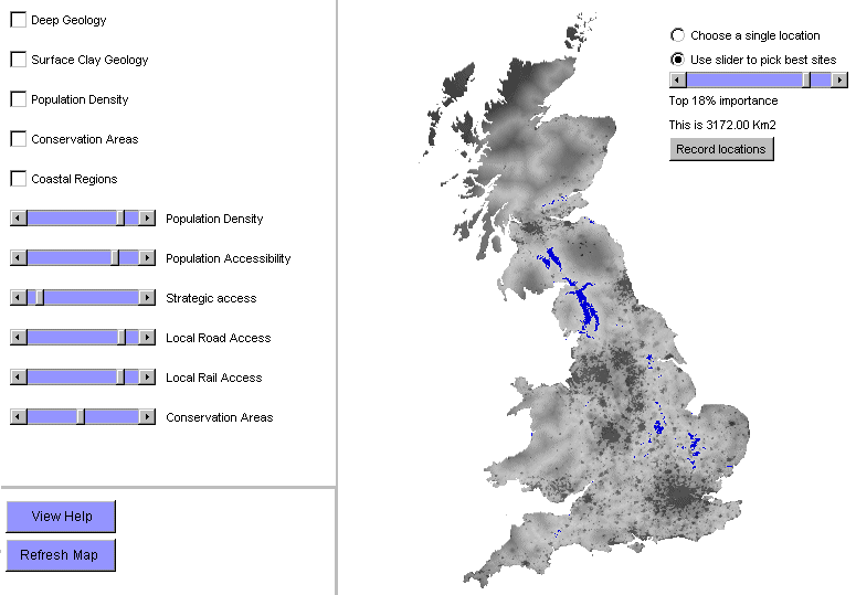
On a more regional scale, a project has been set up with the Yorkshire Dales National Park Authority. The Authority have proposed a 50% increase in the "natural" woodland in the National Park over the next 25 years (YDNPA, 1995), however, they have not yet fixed the locations that will be planted. Plainly, such a planning problem will involve GIS modelling and the participation of both local communities and tourists in the decision. To involve these groups in the planning process a web-based decision-making environment has been developed (Figure 4), centred around a GIS that allows the public to model a number of possible planting scenarios.
The public is first led through information on the problem and the factors that might constrain the planting locations. They are then asked how important they feel specific influences should be (for example, how important, on a sliding scale between totally important and totally pointless, are protected grassland areas?). A map of potential reforestation areas is then generated from these inputs, and stored as an example of the user's opinion prior to exposure to the GIS. The user is then allowed to regenerate the map on the fly by changing the weighting of the factors, and is allowed to set certain influences as absolute constraints (for example, areas of special scientific interest). This allows the users to experiment with hypotheses, and see the implications of their choices. At the same time, the users are allowed to browse in-depth information that is provided through a tree hierarchy, with more detailed information on each subject further down the tree. The tree system was designed to encourage the exploration of information to a level of detail the user felt comfortable with. Meta-information is also provided on how the spatial data has been derived, its errors, and how the system works. After the user has reached an informed decision, the final weightings are recorded. As with the Slaithwaite system, demographic and usability data are collected from each user.
The system has been implemented wholly in built-from-scratch Java and JavaScript to facilitate its distribution as a stand-alone package. The software was designed to be fully controlled from the invoking html pages, allowing its use on a wide variety of projects.
Figure 4: Yorkshire Dales National Park Reforestation web site (click on image for example interface)
http://www.ccg.leeds.ac.uk/atomic/
The national scale study, which is still at the prototype stage, aims to enhance public participation in the planning of disposal sites for Britain's low to intermediate level nuclear waste. At present the responsibility for organising this disposal lies with United Kingdom Nirex Limited (NIREX). At present most of this waste is stored at Drigg, near Sellafield in Cumbria. A recent plan to build a deep repository at Sellafield was prevented, at least in the final instance, by adverse public sentiment to the scheme in the run-up to the 1997 general election, when the government at the time chose to reverse its long-term plans on the matter. Since this period, the matter has been in review by the House of Lords Select Committee on Science and Technology's Enquiry into the Management of Radioactive Waste, culminating recently in the 1999 Report that recommended increased public participation in the planning process.
As one branch of this public participation, an online GIS-centred decision-making environment is under development with the support of NIREX, based on the system of Carver et al. (1997) (Figure 5). The software used is broadly that developed in the Yorkshire Dales National Park study. It is felt that, given the emotive nature of the problem, it is important to garner the views of users prior them to seeing their views expressed as a map of potential locations. The prospect of having NIREX as a neighbour has been known to change even the most deeply felt opinions. Thus, the application again begins with a non-spatial walkthrough of the important influences, which the user is asked to weight prior to a map being generated from these weightings. The user is then supplied with the ability to change the map weightings on the fly, and view a hierarchy of information and meta-information. Environmental organisations and the nuclear waste industry have been approached to provide the information, and comment on each other's information, in the hope of producing a set of data the public trust, or at least understand the provenance of. In addition, the public has the ability to provide text information on the site, and link in this to their own web sites with multimedia contents. The same area of the decision-making environment can be used to discuss the information given by the "official" organisations. It is hoped, when the full version goes online, that there will also be an email discussion group that can be used to review the progress of the disposal programme.
The system has largely been implemented in built-from-scratch Java and JavaScript to facilitate its distribution as a stand-alone package, however, the discussion areas, by their nature, can only be used over the internet, and have therefore been implemented as server-side perl scripts.
Figure 5: Disposing of Britain's Nuclear Waste web site (click on image for example interface)
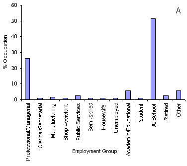
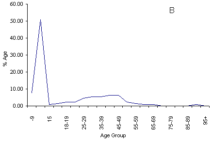
Graph 1: A) Occupation of the users of the "Shaping Slaithwaite" web site B) Age of the users
With both the PfR map and the online map, users were asked how empowered they felt after they had used the system. The responses are listed in Table 1. In both cases the totals do not represent the complete set of users, as people frequently left directly after submitting their opinions. This option will be rectified in future online versions.
Table 1: Results of user empowerment surveys for the PfR and online maps (CVT, 1999a)
| PfR | Online | |||
|---|---|---|---|---|
| Number | Percentage | Number | Percentage | |
| I have full control | 0 | 0 | 3 | 9 |
| I have some power to make changes | 8 | 28 | 9 | 26 |
| I have voiced my opinion but have no power to make changes | 9 | 31 | 13 | 37 |
| I have been asked what I think | 7 | 24 | 10 | 28 |
| I have been told what changes will happen | 5 | 17 | 0 | 0 |
| I have no involvement in changes | 0 | 0 | 0 | 0 |
| I have no opinion | 0 | 0 | 0 | 0 |
Thus the data suggests that people had marginally more trust in the online system to represent their views to those in power. This will, of course, reflect both the system and the skewed user base, and further research into determining which effect is stronger is planned for the larger datasets expected from the other studies.
A larger problem is the limited use or unavailability of the web in certain sections of society. The present research program tackled the availability problem in Slaithwaite by taking PCs to the users, and is in the process of developing the other two projects as stand-alone applications. These will be sent to schools and libraries, with alternative running modes for those institutions that do not have Internet access. The returned data will be collected on disk through the mail. PCs are also to be taken to four visitor's centres during the Yorkshire Dales National Park project. National Government policy in Britain is to increase access to the "information superhighway" through the provision of public access terminals in libraries and public buildings (DfEE, 1997; DfEE, 1998). The Government has also negotiated cheap access for state schools. Access through such environments has the advantage that terminals can be limited to specific decision-making sites when necessary. Internet use in Britain is increasing at a rate of 10,900 new adult users in Britain every day, with at least 10.6 million adults accessing the Internet at least once during 1998 (NOP, 1999). However, actual use in the home is still being stifled by the lack of free local telephone calls that are commonplace in North America. Recent surveys (NOP, 1997 and NOP, 1998) estimate that around a quarter of British households have a PC, however regular online activity is restricted to only half of these.
The apparent reluctance for specific sections of society to use the technology, even when available, will doubtless improve for the Internet as it has done for the telephone, video, and mobile phones. In the meantime, it is apparent from the Slaithwaite study that educational visits can mobilise sections of the community, and this will be a large component of future studies. There are also signs that the emergence of free service-providers in Britain is widening the social spectrum of Internet users. Users are being attracted who are "generally older and from the C2DE social groups - where previously, users had been from predominantly younger age groups and ABC1 social groups" (NOP, 1999). Despite this, the future of these technologies probably relies on their integration with TV-based web browsers and the companies that produce them supporting web-based programming languages. While this is not the case at present, there is a strong commercial impetus to match TV-based browsing to the quality of that from computers.
In Britain there is a further problem with spatial data supply that could well strangle these kinds of democratic projects before they become common, and that is the issue of data copyright. At present, much of the mapping data in the country is held by the Ordinance Survey, a taxpayer funded organisation that is moving towards 100% cost returns from data sales. Recent outreach has been mooted by the organisation towards research use of their data on the Internet, and the Ordnance Survey see the web as a useful tool for distributing their data to clients (Ordnance Survey, 1997). However, the recently released pricing policy for publishing OS data on the Internet (Ordnance Survey, 1999) is prohibitively expensive for both academic and non-profit organisations.
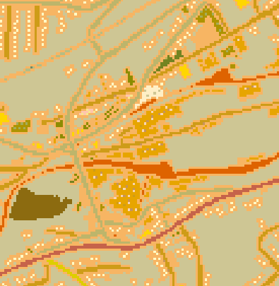
It appears that one of the main worries of the OS is that data served over the Web could be extracted and manipulated in a proprietary GIS package, circumventing the purchasing and copyright costs of buying map data directly from them. Figure 6 represents the results gained from taking a bitmap screen shot of the Slaithwaite web site, saving it as a tiff file and carrying out the imagegrid command in Arc/Info. Clearly the quality of this data as a representation of the village is far inferior to any paper map or OS Land-Line® data. The benefits of attempting to take an image from a web site and transport it into a GIS package are very few. Methods of serving the data across the web in a format that only allows access to the final screen image should provide a safe data environment.
Figure 6: Results from attempting to recreate GIS-ready data from a web-based map
CVT. 1999a Shaping Slaithwaite, Part One - The Process Colne Valley Trust.
CVT. 1999b Shaping Slaithwaite, Part Two - The Proposals Colne Valley Trust.
Carver, S., Blake, M., Turton, I, and Duke-Williams, 1997, Open spatial decision-making: evaluating the potential of the World Wide Web in Innovations in GIS 4, Kemp, Zarine, Taylor and Francis.
DfEE, 1997, Conecting the Learning Society [Online] http://www.dfee.gov.uk/grid/consult/index.htm Department for Education and Employment, Britain, 4 May 1999.
DfEE, 1998, National Grid for Learning [Online] http://www.dfee.gov.uk/grid/challenge/index.htm Department for Education and Employment, Britain, 4 May 1999.
Healey, P., McNamara, P., Elson, M., and Doak, A., 1988, Land Use Planning and the Mediation of Urban Change Cambridge University Press.
Ordnance Survey, 1997, Developments for the World Wide Web (WWW) Information paper 13/1997. Southampton: Ordnance Survey.
Ordnance Survey, 1999, A new pricing policy for mapping on the Internet Information Paper 1/1999 Version 2. Southampton: Ordnance Survey.
NOP, 1997, One in twenty five British households now linked to the Internet [Online] http://www.nop.co.uk/internet/surveys/in07.htm NOP Research Group, 4 May 1999.
NOP, 1998, Kids surf the net [Online] http://www.nop.co.uk/internet.asp/ NOP Research Group, 4 May 1999.
NOP, 1999, More that 10,000 new users try the internet each day in Britain � survey findings [Online] http://www.nopres.co.uk/news/Ticker_Tape/internet.htm NOP Research Group, 4 May 1999.
YDNPA, 1995, The Dales Woodland Strategy Yorkshire Dales National Park Authority, Leyburn.
Andrew Evans, no date, Homepage [Online] School of Geography, University of Leeds, Britain, http://www.geog.leeds.ac.uk/staff/a.evans/ Accessed 4 May 1999
Richard Kingston, no date, Homepage [Online] School of Geography, University of Leeds, Britain, http://www.geog.leeds.ac.uk/staff/r.kingston/ Accessed 4 May 1999
Steve Carver, no date, Homepage [Online] School of Geography, University of Leeds, Britain, http://www.geog.leeds.ac.uk/staff/s.carver/ Accessed 4 May 1999
Ian Turton, no date, Homepage [Online] School of Geography, University of Leeds, Britain, http://www.geog.leeds.ac.uk/staff/i.turton/ Accessed 4 May 1999
Centre for Computational Geography, no date, The Centre for Computational Geography [Online] School of Geography, University of Leeds, Britain, http://www.geog.leeds.ac.uk/research/ccg.html Accessed 4 May 1999
School of Geography, no date, School of Geography - Leeds University [Online] School of Geography, University of Leeds, Britain, http://www.geog.leeds.ac.uk/ Accessed 4 May 1999
University of Leeds, no date, University of Leeds [Online] University of Leeds, Britain, http://www.leeds.ac.uk/ Accessed 4 May 1999
Centre for Computational Geography, no date, Virtual Decision-Making in Spatial Planning [Online] School of Geography, University of Leeds, Britain, http://www.ccg.leeds.ac.uk/groups/democracy/ Accessed 4 May 1999
ESRC, no date, Virtual Society? Homepage [Online] Brunel University, Britain, http://www.brunel.ac.uk/research/virtsoc/ Accessed 4 May 1999
Slaithwaite Community, no date, vill [Slaithwaite Village Homepage] [Online] Raven Computers, Britain, http://www.digitalhighway.co.uk/slaithwaite/ Accessed 4 May 1999
Neighbourhood Initiatives Foundation, no date, nif@cablenet.co.uk [Email address] Cablenet, Britain, nif@cablenet.co.uk Accessed Summer 1998
Centre for Computational Geography, no date, GeoTools [Online] School of Geography, University of Leeds, Britain, http://www.ccg.leeds.ac.uk/geotools.html Accessed 4 May 1999
Centre for Computational Geography, no date, The Slaithwaite Virtual Decision-Making System [Online] School of Geography, University of Leeds, Britain, http://www.ccg.leeds.ac.uk/slaithwaite/ Accessed 4 May 1999
Yorkshire Dales National Park Authority, no date, The Yorkshire Dales National Park [Online] Yorkshire Net, Britain, http://www.yorkshirenet.co.uk/visinfo/ydales/ydnp.html Accessed 4 May 1999
Centre for Computational Geography, no date, Yorkshire Dales National Park Woodland Planting Project [Online] School of Geography, University of Leeds, Britain, http://www.ccg.leeds.ac.uk/dales/ Accessed 4 May 1999
United Kingdon NIREX Limited, no date, NIREX homepage [Online] United Kingdon NIREX Limited, Britain, http://www.nirex.co.uk/ Accessed 4 May 1999
House of Lords Select Committee on Science and Technology, 10 March 1999, House of Lords - Science and Technology - Third Report [Online] HMSO, Britain, http://www.parliament.the-stationery-office.co.uk/pa/ld199899/ldselect/ldsctech/41/4101.htm Accessed 4 May 1999
Centre for Computational Geography, no date, Disposing of Britain's Nuclear Waste - Prototype [Online] School of Geography, University of Leeds, Britain, http://www.ccg.leeds.ac.uk/atomic/ Accessed 4 May 1999
Ordinance Survey, no date, Ordinance Survey: Britain's national mapping agency [Online] Ordinance Survey, Britain, http://www.ordsvy.gov.uk/ Accessed 4 May 1999
James Macgill, no date, James Macgill's Homepage [Online] School of Geography, University of Leeds, Britain, http://www.geog.leeds.ac.uk/pgrads/j.macgill/home.html Accessed 4 May 1999
MetroMap displays community/government information for Portland, Oregon, that can be layered by the
user or used to generate lists of boundary information.
Metromap, no date, Metromap Help [Online]
http://www.metro.dst.or.us/metromap/ Metro regional services, Portland, Oregon, USA, 5 May 1999.
Britain's Brent Council offers a number of map based online information services.
Brent Council, no date, LA 21 On-line Consultation [Online]
http://www2.brent.gov.uk/recycle.nsf Brent Council, Britain, 5 May 1999.
Friends of the Earth offer a number of map based searches for local environmental problems.
Friends of the Earth, no date, Friends of the Earth Home Page [Online]
http://www.foe.co.uk/ Friends of the Earth, Britain, 5 May 1999.
Planning Applications in County Wicklow can be browsed online
County Wicklow, 1998, Planning Applications in County Wicklow - Interactive Mapping System
[Online] http://www.wicklow.ie/planning/ Wicklow County Council, Eire
5 May 1999.
An early online GIS system that allowed for public participation is that of Carver et al.
(1997)
Centre for Computational Geography, 28 March 1996, Open Spatial Decision Making on the Internet [Online]
http://www.ccg.leeds.ac.uk/mce/
School of Geography, University of Leeds, Britain, 5 May 1999.
Present research by the authors, that extends the work of Carver et al.
(1997) can be found at the VDMISP project page [This is now Democracy Group pages - link changed (edit 15 May 2007)]
Centre for Computational Geography, no date, Virtual Decision-Making in Spatial Planning [Online] School of Geography, University of Leeds, Britain,
http://www.ccg.leeds.ac.uk/groups/democracy/ Accessed 4 May 1999
The MIT Computer Resource Lab have a number of online spatial projects
MIT Computer Resource Lab, no date, CRL Research Projects [Online]
http://gis.mit.edu/projects/ MIT, USA, 5 May 1999.
Research work is also underway by GDM's Knowledge Discovery Team on a web-based GIS "Descartes"
Knowledge Discovery Team, no date, AiS - Knowledge Discovery Team [Online]
http://borneo.gmd.de/KD/ GDM, AiS, Germany, 5 May 1999.