![[first Matrix]](cap1.gif)
Accessibility as an important wilderness indicator:
Modelling Naismith's Rule
Steffen Fritz and Steve Carver
School of Geography
University of Leeds
Fax: 0113 233 3308
E-mail: s.carver@geog.leeds.ac.uk
1. Introduction
There has been a constant rise in outdoor recreation in the last 40 years and substantial increases are predicted in the next several decades (Ewert and Hollenhorst, 1997). The countryside is no longer viewed solely as a geographical unit of agricultural production, but as an environment for active recreation and aesthetic enjoyment. For many people, active outdoor recreation promotes a healthier lifestyle and provides a therapeutic release from the stresses of work and everyday life (McDonald,1991). People tend to access remoter areas in order to experience the 'wild'. In the UK it is mainly the upland areas, especially those of the Scottish Highlands, that offer at least some characteristics of a 'wilderness experience'. With greater use of these 'wilder areas' concerns have increased over the destruction of the last vestiges of the very thing we seek; wilderness.
To support management and policy decisions it is necessary to assess wilderness condition on a range of scales. On a local scale accessibility of the landscape is a crucial wilderness indicator. A method to determine this wilderness indicator is introduced here and broader applications of accessibility mapping are addressed. Wilderness mapping that has been done on a national level is briefly described, while the requirements and differences for a local level survey are explored. Within this, the so called Naismith's Rule is introduced in combination with the shortest path algorithm to model walking time in an open landscape. Applications are described for two case study areas, the popular Dark Peak area of the Peak National Park and the Cairngorm mountains in Scotland.
2. Mapping wilderness on a national level
What is wilderness? This crucial question affects all allocations of wilderness areas. Several authors (e.g. Lesslie and Taylor, 1985; Hendee et al., 1990) agree that there is no generally accepted or universally applicable definition of wilderness. Each definition depends on the philosophical view of the person who defines it. The anthropocentric concept emphasises the experiential benefits which can be derived from direct human use of undeveloped land, particularly those focusing on the benefits of recreation within a natural setting. In contrast, biocentric wilderness inventories usually define wilderness in terms of the conservation and preservation of natural ecosystems.
Following just one of the above philosophical concepts leads to a rather one sided approach, and so both need to be considered when defining wilderness. As Lesslie (1985, p.5) remarks: "wilderness is an amalgam of both concepts and wilderness definitions exclusively based upon either concepts are merely incomplete". Most recognised definitions agree that wilderness can be somehow defined as the extent to which nature is changed or disturbed due to the influence from modern society with its attributes remoteness and primitiveness.
The use of GIS for wilderness mapping on a national level has only been developed recently. Most wilderness maps which have been produced with the aid of GIS originate from the approach which has been developed by the Australian Heritage Commission (AHC) in 1988. This approach to a wilderness inventory is not matched to either a biocentric or anthropocentric view and involves assessment of remoteness and primitiveness based upon the definition of wilderness as undeveloped land which is relatively remote, and relatively undisturbed by, the process and influence of settled people (Leslie and Taylor, 1985, Lesslie and Maslen, 1995). From this definition four wilderness indicators are defined. These include:
1. Remoteness from Settlement - remoteness from points of permanent human occupation;
2. Remoteness from Access - remoteness from constructed vehicular access routes (roads) and railway;
3. Apparent Naturalness - the degree to which the landscape is free from the presence of the permanent structures of modern society; and
4. Biophysical Naturalness - the degree to which the natural environment is free of biophysical disturbances due to the influence of modern society.
(After Lesslie, 1995)
In highly populated areas such as Britain and most places in Europe, a model that takes into account all features which are located in a certain radius is much more appropriate. This has led to a map definition of wilderness based on a distance decay model being developed. This model is a applied for populated cells, remoteness from access and apparent naturalness as follows:
1. Remoteness from population - based on the 1991 UK Census of Population an population weighted exponential distance decay model is applied on a 1 km grid resolution;
2. Remoteness from access - remoteness from access is also based on an exponential weighted distance model taking into account all forms of mechanised transport route (except air traffic) from the Bartholomew's 1:250,000 datasets;
3. Apparent Naturalness - again, for mapping apparent naturalness the above weighted distance decay function is used by taking into account all highly visible non-natural features such as radio masts, railway lines, roads, settlements, urban areas, etc; and
4. Biophysical Naturalness - ITE land classification data is used to derive a map indicating the likelihood of finding natural or near natural ecosystems from a weighted distribution of land cover types.
All the datasets were derived and analysed using the GRID module in the ARC/INFO GIS.
In order to take the subjective nature of the wilderness concept more into account, multicriteria evaluation (MCE) techniques can be used to weight the wilderness indicators differently. This allows the wilderness continuum to be mapped for the whole study area, describing a continuous surface from the least to the most wild locations (Carver, 1996). A simple weighted linear summation model is used here with the above datasets and a range of different weighting schemes to produce a variety of continuum maps for Britain. This approach avoids a number of problems with the basic Australian approach:
1. datasets are treated as continuous without the need for defining rigid wilderness criteria and so retain their full information content;
2. the datasets are not presumed to be of equal weight thereby allowing individual perspectives to shape the model outcome; and
3. the resulting wilderness continuum is relative and therefore does not prejudge the presence or absence of wilderness within a study area as defined by any threshold value.
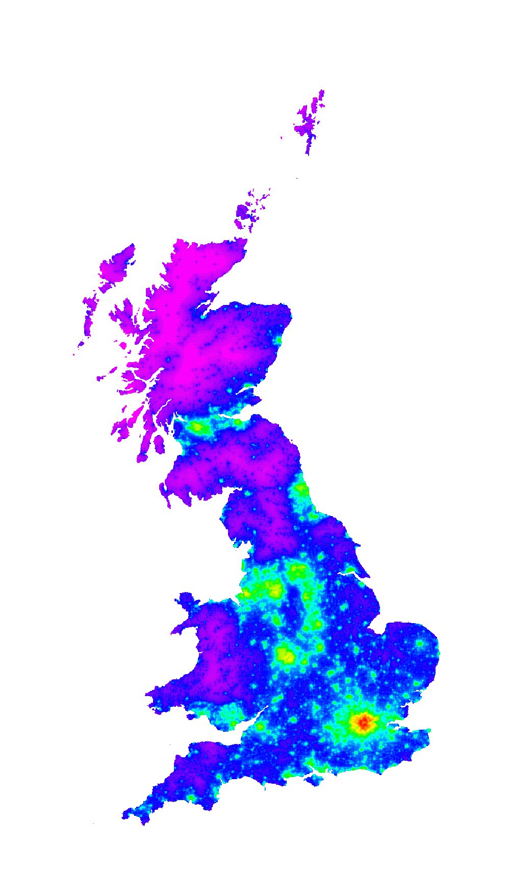
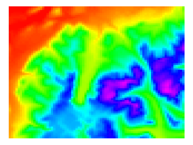
The wilderness continuum map of Britain that stresses remoteness factors is shown in figure 1 by way of example.
Figure 1 Wilderness continuum stressing remoteness factors
3. Mapping the wilderness continuum at a local level
The mapping described above works well as a national reconnaissance level survey. Close examination of individual areas, however, reveals certain inconsistencies. A more detailed local level study can deliver more reliable data. In order to map wildland areas at a local level, other wilderness indicators need to be taken into account. Firstly, much finer resolution data can be used and additional datasets can be considered, for example footpath data, reservoirs and car parks. One crucial factor strongly influencing the perception of wilderness is remoteness. Remoteness is not only to be described in terms of distance from roads, but also in terms of accessibility to a certain terrain structure. On a local level it is possible to develop a model that takes into account the topography and isolation of the area as perceived by a walker on the ground. A method of measuring accessibility is a time measure of walking distance. This can be achieved by considering Naismith's Rule.
3.1 Naismith's Rule
W.W. Naismith was a founder of the Scottish Mountaineering Club and a formidable walker and his rule is still used to obtain a rough estimate of the time required for a given expedition (Aitken, 1977; Langmuir, 1984). It is thought that the rule gives a reasonable minimum time, but due to the fact that Naismith was an optimist it is proposed by Wilderness Tech Tips (1998) to take the Naismith value and add 50 %. Additional time can be added according to rests, extra carried weight, poor weather and rough underfoot conditions. The basic rule of Naismith states that a walker can maintain a speed of 5 km/h on level ground, but 1 hour needs to be added for every 600m of ascent. Several refinements to Naismith's Rule have been made and another rule, the so called Backpacker's Rule, has been defined (Wilderness Tech Tips, 1998). Aitken (1977) makes refinements according to ground conditions. This assumes that 5 km/h can be maintained on paths tracks and roads, while this is reduced to 4 km/h on all other grounds. Langmuir (1984) makes following further refinements:
Naismith's Rule: 5 km/h plus 1 hour per 600m ascent; minus 10 minutes per 300 m descent for slopes between 5 and 12 degrees; plus 10 minutes per 300m descent for slopes greater than 12 degrees.
Kennedy (1998) states that the rule is applicable to reasonably fit hillwalkers negotiating typical terrain under typical weather conditions. Furthermore he mentions the following factors as having a significant effect on route times:
Terrain and conditions Underfoot
It has to be noticed that only on a good footpath can Naismith's speed of 5 km/h be readily maintained and that on a densely vegetated trackless terrain, hag-ridden ground, or boulder fields a 'time penalty' must to be added. Additionally, Naismith's climbing rate (600m per hour) is unlikely to be achieved whilst rock scrambling. Furthermore, winter conditions can change the walking time remarkably. For example, a cover of soft and drifted snow or snow with a breakable crust can make walking conditions extremely difficult.
Weather
Wind is the most important meteorological factor. Kennedy (1998, p.3) remarks "a strong headwind can more than halve walking speed, a strong crosswind on a exposed ridge can also impede process, by forcing frequent stops to avoid getting blown off!" and "coincidental hail, sleet or snow can add to the trauma - particularly if effective eye protection is not available".
Descent
Naismith's formula makes no special allowance for downhill sections, and only the map distance covered is taken into account at the standard walking pace. The reason why during steep descents a delay occurs is mainly due to the need to take shorter steps, or to reduce the slope angle and extend path length by zig-zagging. Due to the fact the descent affects walking time, the refinements made my Langmuir in 1984 are taken into account and his rule used to model time distances in the current analysis (see section 3.3).
Fitness and load carried
Another factor which obviously contributes to the walking time into an area is the fitness of the hillwalker. Kennedy (1998, p.4) mentions Tranter's correction to take an individual's fitness into account: "An allowance can be made for this factor by use of Tranter's correction. This is in the form of a table, where the basic Naismith estimate for a route is modified by a factor which is dependent on individual fitness level; this in turn can be determined by recording the time taken to climb a set height (300m) over a set distance (800m) at normal walking space. Whereas Naismith's Rule assumes a steady rate, Tranter's correction takes into account the effects of fatigue, such that a reduced mean work rate is assumed for the more demanding excursions."
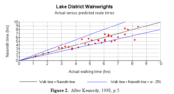
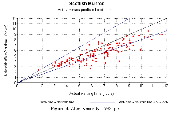
In a study by Kennedy (1998) the ascent time for peaks in two areas were chosen to investigate the reliability of Naismith's Rule; the Lake District 'Wainwrights' and the Munros in the Scottish Highlands. In this study the original Naismith's Rule was applied without Tranter's correction and with no additional allowance made for scrambling routes or steeply descending pitches.
Figure 2 shows that Naismith's Rule is a good predictor for walking time in the Lake District hills within a percentage of 25 percent. On another terrain walking distances may differ significantly. This is the case in the Scottish Munros. Differences occur due to the amount of scrambling required on these routes and the more serious nature of winter routes (most of the points below the lower 25% line are scrambling or winter routes). Furthermore, when walking long distances, a 'fatigue factor' is revealed. This is shown in figure 3.
3.2 The problem of finding the shortest path within an open terrain represented by a Digital Elevation Model (DEM)
A Digital Elevation Model (DEM) is used to represent a landscape surface that will be accessed by walkers from access certain points or roads. Accessibility from different directions to access the same landscape should be considered and the shortest access time should always be taken into account. A model is developed that gives information about the time needed to walk from one source point to all other points on the surface. Due to the fact that it is unknown which route walkers will take, only the shortest possible path to that source point is to be considered in the model. By using this model, it is possible to allocate those areas that have a specific time distance from the source point and therefore acquire information about areas that are relatively inaccessible. This gives information about the level of remoteness and to what extent it contributes towards the wilderness value of that location. The shortest path algorithm, known as Dijkstra's algorithm, offers a possible optimal solution to the problem.
3.2.1 The shortest paths algorithm
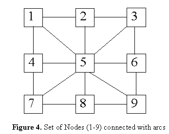
In order to describe this model in an mathematical way the notion of a directed graph is introduced. A directed graph consists of a set of nodes, and a set of arcs. In figure 4 the nodes 1 - 9 and their connected arcs are shown. This can be regarded as a 'simplified representation' of the landscape surface. Each of the nodes 1- 9 represents a certain height and each arc represents a certain 'time distance' to walk from a location to the connected neighbour and vice versa.
In this case there is a set of nodes (1-9) and a set of arcs (1,2), (2,1), (1,5), (5,1), (1,4), (4,1), (2,3), (3,2) etc.
Figure 4 Set of Nodes (1-9) connected with arcs
N is the name for the set of nodes, that is N = (1,2,3,etc.) and if A is the name for the set of arcs, then A = {(1,2), (2,1), (1,5) etc.}. A graph consists of a set of nodes and a set of arcs and is written G =(N,A) to mean that N is the set of nodes and A is the set of arcs. The length of an arc l can be represented as a distance and direction going from node i to node j. A path then is a sequence of arcs by following each arc in its given direction from node o to node ik. The shortest path problem can be stated as following: given a directed graph G=(N,A) and a specified source s (which is in N) where each arc (i,j) in A has a specified non negative length l (i,j), for each node in N find a shortest path from s to i (Dracos, 1998).
The following steps will find the shortest path - described as the shortest path algorithm in a formal way (see Dracos, 1998):
-{initialise} Set Label(s) = 0 and Label (i) = + for all other nodes i in N. Set j:=0
Let Prev(i) undefined for each node i in N; all nodes are unmarked.
-{Main loop} until all nodes are marked with a * do the following:
1. Set j:=j+1 (go through the hole matrix)
2. Among all unmarked nodes select a node i for which the label is minimum;
3. Mark node i with a *, Set Closest(j):=i;
4. For each arc of the form (i,j) or in other words for each arc leaving node i, compare Label(j) with Label(i) + l(i,j); if latter is smaller, then set
Label(j): Label(i) + l(i,j) and set Prev(j):=i
(Note: in fact it suffices to consider all arcs leaving i that go to unmarked nodes j.)
The proof of the algorithm can be found in Aho et al., 1974 or easier explained in Nicos Dracos, 1998.
3.3 Implementation of the shortest path algorithm by the incorporation of Naismith's Rule
In order to find the shortest path four different matrices are used. The first is the Heights Matrix H(X,Y), the second the Distance matrix D(X,Y) and the third (Trace matrix T(X,Y)) marks all the nodes which have been dealt with. After the last loop in the program the results matrix R(X,Y) delivers the shortest path from one source point to all other points on the DEM. Trace Matrix T(X,Y) and Results Matrix are changed during the analysis process. Figure 4 can be represented as the following matrix each number (1 - 9) representing a certain height (30m represents 1, 90m represents 2, 50m represents 3, 10m represents 4 etc.). This matrix is read as an ARC/INFO GRID file into the memory and looks as follows:
Secondly, the Distance Matrix D(X,Y) is calculated with the use of the Heights Matrix H(X,Y). Matrix D(X,Y has H(x,y)2 dimension, and produces information on time distances and connectivity between arcs. Time distances to get from each point to the neighbour and vice versa are calculated. In the case of a 50m grid resolution DEM for every m climbed, 6 seconds are added. 2 seconds are added in case of a ascent of more than 12 degrees and 2 seconds are subtracted if the ascent is between 5-12 degrees. In each row of D(X,Y) the length of time it takes to get from a point on the left column (e.g. X1Y1) to all the others is recorded. Minus two means that there is no connection. The third matrix T(X,Y) is constantly changed to show those labels with which the program has already dealt with.
The distance matrix D(X,Y) looks accordingly as following:
![[first Matrix]](cap2.gif)
When specifying a source point H(X1Y3) of the heights matrix following steps occur. Firstly, the source point will be considered and all possible connections to the source point are examined. The first loop will scan through line 7 of Matrix D(X,Y) and write to Results Matrix D1 (X,Y). The source point will be marked in the Trace matrix T1(X,Y) to indicate that the co-ordinate X1Y3 does not need to be considered for a second time. It is then scanned through the results matrix D1 to find the co-ordinates (X2Y3) of the smallest number (69). This point is marked in the Trace Matrix T2.
After the first loop the Trace and the Results matrix looks like that:
![[first Matrix]](cap3.gif)
The next loop scans through line 8 to look for connection and time distances from point X2Y3 to its neighbours. It then adds 69 to the values of that line and writes the results to a Compare Matrix C (X,Y). Results Matrix R1(X,Y) and Compare Matrix C1(X,Y) are compared and the smallest value of the two is taken and written in the new Results Matrix R2(X,Y). All those points formerly marked infinity (-2) are also replaced whenever a value has been found/ a connection to that point has been established.
![[first Matrix]](cap4.gif)
![[first Matrix]](newr.gif)
:
etc.
The loop stops when the Trace Matrix all nodes have been dealt with and the Trace matrix looks as follows:
![[first Matrix]](newtr.gif)
The loop gradually scans through the whole distance matrix and delivers the optimal shortest path. This is the results Matrix Rlast (X,Y) because there is no path any more which is shorter.
3. 4 Accessibility in the Peak District at different locations
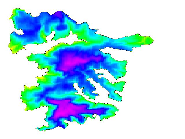
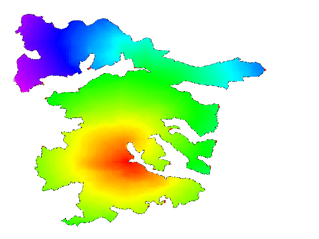
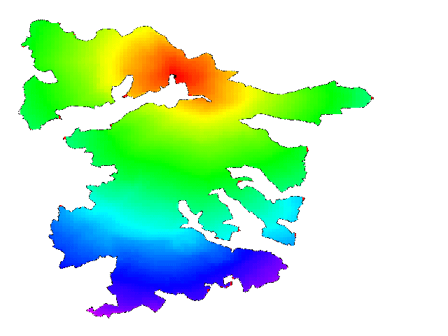
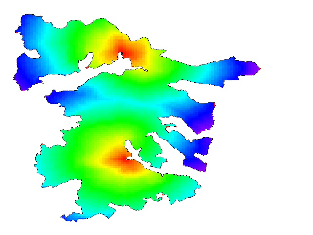
The described algorithm is applied in the Dark Peak District which contains a number of access areas within which the public have the right to roam. One access area is shown in figure 5 overlain on a 200m resolution DEM. Figures 6 and 7 show the accessibility within this area when entering at a particular location. For illustration the two access points are considered and figure 8 is produced by simply comparing figures 6 and 7 and taking the smallest time value.
Figure 5 Dark Peak DEM and access area
Figure 6 Accessibility surface for northern entry point
Figure 7 Accessibility surface for southern entry point
Figure 8 Combined accessibility surface for northern and southern entry points
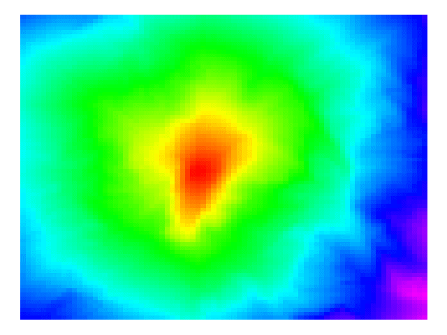
3. 5 Accessibility in the Cairngorm Mountains
Time distances are located more or less circlewise in the Peak District due to the limited height range affecting the walking time. In order to illustrate the effects of greater height differences the model is applied in the Cairngorm mountains of Scotland. The DEM for this area is shown in figure 9. The effects of a strong increase in height can be seen by placing an access point in the centre of the area shown in figure 9. The resulting accessibility surface is shown in figure 10 which clearly illustrates the effect of terrain on off road access times.
Figure 9 Cairngorm mountains DEM
Figure 10 Accessibility surface for central access point
3.6 Possible refinements to the algorithm
As discussed in section 3.1, refinements and changes to the rule according to certain factors can be made. Where some factors affecting walking time cannot be incorporated into the model others can. Underfoot conditions are a factor which can be taken into consideration. This can be achieved by scanning a grid which represents vegetation changing the distance values accordingly. In the same way inaccessible areas such as lakes can be taken into account. Additionally legal right of access can be considered. Furthermore, barriers for very steep slopes and cliffs can be considered. According to the fact that people walk faster on a footpath, these grids could be made recognisable by the algorithms and a 'time gain' could be correspondingly assigned. In the same way, the algorithms could be easily changed and applied to scrambling routes by recognising steep slopes and assigning additional time penalties. Furthermore, the rule can be calibrated for a specific region and different time distances can be assigned on another terrain.
3.6 Applications
This algorithm has multifunctional application. It could simply serve as an information system (e.g. tourist information system) for walkers when planning a walk or trip. Here the described refinements to the rule can be made and individual fitness and walking times of a group can be taken into account. When using this algorithm for accessibility different scenarios can be modelled, for example, what happens when specific entrance gates are closed (e.g. when breeding birds should not be disturbed) and which gates need to be closed when the carrying capacity in a certain area is being exceeded. A further application of this algorithm can be in the areas of emergency planning. This model allows to predict with a certain likelihood where people could possibly be when missing and which areas are simply inaccessible within a certain time. This would allow to develop more accurate search strategies for rescue teams, particularly when looking for individuals/groups when weather conditions have changed or avalanches have occurred. The described algorithm can be extended to also show the shortest path itself by adding an additional matrix which records the co-ordinates of the shortest path.
4. Conclusions
This paper demonstrates how the implementation of Dijkstra's shortest path algorithm is valuable for accessibility mapping where there is freedom to roam access. The results shown in figures 6, 7, 8 and 10 indicate that the model works well, although the effect of terrain over simple horizontal distance is more noticeable in higher relief areas.
The main problem concerning development and application is that of computational complexity. Although implemented within a GIS framework, the model is very computationally intensive and requires a great deal of CPU time and memory. This limits the application of the model to relatively small input DTMs in the order of 200 by 200 cells. In case a larger terrain is to be mapped, memory problems can occur as the distance matrix D (X,Y) is of n4 dimension. Due to the fact that there is a huge number of unconnected nodes there are methods to decrease the dimension of this matrix in order to reduce memory requirements. Should these improvements still not allow the mapping of a large area the use of a supercomputer is required.
Further work is planned in incorporating other time penalties to the basic shortest path based application of Naismith's Rule described here. These include the effect of ground cover and conditions, the effects of barrier features such as impassable rivers, lakes and crags and also the effect of Tranter's correction. Additional modifications will be carried out to allow the algorithm to be applied to linear access features such as roads and tracks. The algorithm will be applied as part of a wider on-going study of wilderness quality mapping in Scotland focusing on local case studies in Knoydart, Letterewe/Fisherfield Forests and the Cairngorm mountains.
References
Aho, A. V., Hopcroft, J. E., and Ullmann J.D. (1974), The Design and Analysis of Computer Algorithms, Addison-Wesley Publishing Company, Reading
Aitken, R., 1977, Wilderness areas in Scotland, PhD Thesis, Aberdeen University
Carver, S., 1996, Mapping the wilderness continuum using raster GIS, In: Raster Imagery in Geographical Information Systems , High Mountain Press, Albuquerque
Carver, S. J.,1991, Integration multi-criteria evaluation with geographical information systems, International Journal of Geographical Information Systems, 5, 321 - 339
Evert and Hollenhorst (1997), Outdoor Recreation and its implications for wilderness. International Journal of Wilderness, Volume 3, Number 2
Hendee, C.J., Stankey,G.H. and Lucas, R. C., 1990, Wilderness Management, Fulcrum Publishing, North American Press, Colorado
Kennedy, P (1998) Wilderness Rules.
Available from http://www.gillean.demon.co.uk/Naismith/Naismith.htm, Accessed 24th Feb. 1998
Langmuir (1984) Mountaincraft and Leadership - the Sciottish Sports Council/ The Mountainwalking Leader Training
Lesslie, R. G. and Taylor, S. G., 1985, The Wilderness Continuum Concept and its Implication for Australian Wilderness Preservation Policy, Biological Conservation, 32, 309 - 333
Lesslie, R.G, and Maslen, M., 1995, National Wilderness Inventory Handbook of Procedures, Content and Usage (Second Edition), Commonwealth Government Printer, Canberra
McCloskey, J. M., Spalding, H., A., 1989, A reconnaissance- Level Inventory of the Amount of Wilderness Remaining in the World , 1989, Vol 18, p. 221- 227
Drakos, N (1998), The shortest path algorithm, Cornell University
Available from: http://www.orie.cornell.edu/~or115/handouts/handout3/handout3.html
Accessed 20th Feb. 1998
Wilderness Tech Tips (1998),
Available from: http://www.edgeinternet.com/wtc/tips.htm, Accessed 24th Feb. 1998