Web Based GIS for Public
Participation Decision Making in the UK
Richard Kingston
School of Geography
University of Leeds
England
Abstract
This paper outlines current research examining the potential of the WWW as a means of increasing public participation in environmental decision making. The paper considers traditional methods of public participation and argues that new internet based technologies have the potential to widen participation in the planning system. Evidence is provided of the potential and actual benefit of on-line spatial decision making systems in the UK through three real environmental decision making problems at the local, regional and national scale.
Introduction
The research which is outlined in this paper is part of a wider Programme of work currently being undertaken in the UK. The Economic and Social Research Councils (ESRC) Virtual Society? Programme aims to examine if there are fundamental shifts taking place in how people behave, organise and interact as a result of emerging electronic technologies.
The rise of the Internet and the World Wide Web (WWW) has created many opportunities for those involved in Geographical Information Systems (GIS) and decision support research. Recently many GIS have appeared on the Web (Carver, in press). These systems tend to vary in nature from simple demonstrations and references to GIS use through to FAQs and more complex on-line GIS and spatial decision support systems. The level of functionality among these GIS systems is also variable giving the general public, or at least those with a connection to the Web, access to a variety of both GIS systems and data. With the potential increased availability, previous criticism of GIS as an elitist technology (Pickles, 1995) may no longer be valid. GIS and the WWW are ever evolving technologies with the potential for public use allowing greater involvement in environmental decision making and "they can design GIS primarily for expert use or they can make them accessible to the lay professional and even to the general public" (Innes and Simpson, 1993, p.231).
To gain an understanding of the potential benefit and the processes by which the public could use, interact and benefit from such systems requires a comprehensive research agenda which can develop, live test and monitor such activities. The research being undertaken by the authors aims to investigate these questions in both a theoretical and practical way. The project is working closely with several organisations in the UK: Kirklees Metropolitan Council Environment Unit, Colne Valley Trust, the Yorkshire Dales National Park Authority and UK Nirex Ltd. in developing prototype systems that are designed to address real decision making problems. These are essential both in providing a substantive focus for the research and development work and in securing widespread public interest.
Aims and Objectives
The overall aim of the research is to critically examine the role of GIS and the WWW in enhancing current decision making processes and infrastructures. In particular, the research concentrates on what role GIS and the WWW are beginning to play in improving public participation in local environmental decisions making in the UK planning system. Specific objectives in addressing these aims are:
Decision Support via the World Wide Web
By providing access to appropriate data, spatial planning models and GIS via user friendly web browsers the WWW has the potential to develop into a flexible medium for enhanced public involvement in the planning process. Several web based systems can now be found on line but the majority of these tend to be demonstration systems using sample data which are not necessarily problem specific and are therefore of little interest to the majority of the public. Many of these systems merely provide information in a uni-directional form such as listing planning applications and publishing information about development plans. The web servers provide information to the client but there is no method by which the client subsequently feeds information back to the server. In the UK Devon County Councils Structure Plan document was put on-line allowing access to documents outlining the Councils strategic policies and proposals (Devon County Council, 1998). Details on how to object to the proposals and the times, dates and places of meeting were also provided. The system lacked any ability for the public to interact with the plan by populating the system with their own information, ideas or objections and was thus uni-directional in operation.
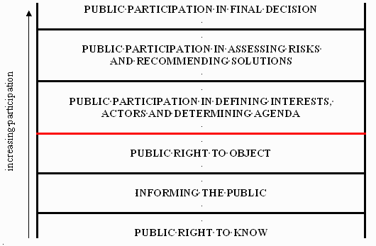
The level of participation in this web based approach is fixed within the bottom two rungs of the public participation ladder (illustrated in figure 1); the public right to know and informing the public. While the Devon web site provides an opportunity for the public right to object this is mainly through the provision of a postal address to send objections. An e-mail address is also provided, but if the system were accessed from a public terminal in a library or community centre for example the user may not necessarily have an e-mail account. The use of a simple on-line form in the web page could easily overcome this problem. The London Borough of Brent have moved a step closer to increasing public participation in local democracy by holding web based forums to discuss local environmental problems such as Local Agenda 21 issues (Brent Council, 1998). This kind of initiative takes a further step in increasing public participation by allowing the discussion and debate of local issues, and could be regarded as step 4 in Figure 1 Public participation in defining interests, actors and agendas.
Figrue1: The Public Participation
Ladder
In order to achieve even greater degrees of involvement in environmental decision making the public need to be provided with systems which allow them to create virtual spaces. Such systems should allow participants to proceed through the following four stage model:
Experimentation with choice alternatives is also an essential part of the learning process. Achievable solution alternatives can be identified and fed into the decision space, while unfeasible or conflict generating alternatives discarded. These kinds of approach, essentially What if? scenarios, are fundamental to many analyses undertaken by a GIS. With this in mind web based GIS should also be capable of allowing the user to:
The final stage in the model, feedback and evaluation of the system, is important for both the client user and server. Feedback to users throughout the decision process is essential to inform how and why particular decision choice alternatives have been identified and also keeps clients aware of how they are formulating their decision choices. Evaluation and feedback of the system by users is also essential to allow server administrators and designers to improve and clarify the systems. As decision alternatives are identified and feedback in both directions builds up continuous changes are likely which will be of benefit to the system as a whole and improve the ability to maximise final decisions.
Traditional vs. On-line Public Participation
Public participation in local environmental decision making, particularly in the UK planning system has traditionally tended to focus on council planning meetings. This is often in an atmosphere of them and us with the authoritative decision makers holding all the knowledge, expertise and information, more often than not positioned on a platform with the general public down below in a less favourable physical and psychological position. It is often the case in these more traditional settings that a vocal minority (activists) dominate the publics viewpoint with many individual citizens hesitating to express their concerns and opinions, and "rarely if ever emerge as definable actors in the development process" (Healey et.al. 1988). This often leaves many people resisting from expressing their concerns, opinions and viewpoints when they may have equally, if not more, valid points to make. Traditionally public participation has been limited to the public right to know, informing the public and the public right to object. The ability to define interests, the actors, determine the agenda, assess risks, recommend solutions and partake in the final decision has traditionally been closed to the public. As figure 1 illustrates the opening up of decision making processes may lead to public involvement further up the participation ladder.
The use of the WWW in such situations has the potential to break down some of the barriers to participation by taking away certain psychological elements which the public face when expressing their points of view at public meetings. As Graham (1996, p.2) argues, the Internet will "generate a new public sphere supporting interaction, debate, new forms of democracy and cyber cultures which feed back to support a renaissance in the social and cultural life of cities". Considering that most peoples concerns regarding their surroundings involve spatial entities (mental maps, landmarks etc.) the use of GIS on the WWW has great potential for popular involvement. Many studies have investigated the ways people perceive and relate to information displayed on a map and how maps can interpret and display information in different ways (Keates, 1996, Wood, 1993). Most people now have concerns over environmental decisions ranging from Local Agenda 21 issues (UNCED, 1992) which have global and local perspectives, to the location of controversial open cast coal sites and smaller scale less contentious developments such as the locating of a new community centre or public library.
In addition to helping answer questions pertinent to new technologies and the publics role in environmental decision making, a significant contribution to the continuing development of theory in the field of decision making is envisaged. This may be achieved through the analysis of web access logs to track the decisions made by users of the on-line systems being developed in this on-going project. Research in the UK is beginning to collect and analyse quantitative and qualitative data on:
Case Studies
Notwithstanding the current limited access in the UK studies are being undertaken to investigate the potential of on-line GIS systems. Research is engaging with users at three spatial scales: local, regional and national. This is shown in Table 1. The village based case study has already taken place and work is now underway on the regional and national case studies.
Table 1: Case Studies
| Description | Locale | Scale | Problem-type | End-user(s) |
| Village-based "Planning For Real" exercise | Slaithwaite, West Yorkshire | Local | Multiple issue | Kirklees Metropolitan Council and Colne Valley Trust |
| Evaluation of the potential for regeneration of natural forest cover | Yorkshire Dales National Park, North Yorkshire | Regional | Single issue | Yorkshire Dales National Park Authority |
| Siting a radioactive waste repository | United Kingdom | National | Single issue | United Kingdom Nirex Limited |
Virtual Slaithwaite
A Planning for Real (PFR) exercise arranged in the village of Slaithwaite by Colne Valley Trust (CVT), a local community action group, for early June 1998 emerged as a good case study to live test a web based GIS. PFR is an idea developed as a means of getting local people more closely involved in local planning decisions through active participation and interaction with large scale models of a community. The Slaithwaite PFR exercise was co-ordinated for the CVT by planning consultants The Neighbourhood Initiative Foundation and part funded by the local council. A 1:1,000 scale three dimensional model of a 2km2 area of the Slaithwaite village and valley was constructed by the CVT and the planning consultants with the help of local school children. This was used as a focus for local discussion about planning issues within the village. Local people were invited to register their views about particular issues by placing flags with written comments on to appropriate locations on the model. The results of this exercise were then collated by the consultants NIF, and were then subsequently fed back into the planning process through appropriate policy documents and plan formulation mechanisms.
The Slaithwaite PFR exercise provided this research project with an ideal opportunity to develop, pilot and live test a simple VDME that mirrored the functionality of the physical PFR model. This was called "Virtual Slaithwaite" and can still be used on-line. The virtual version of the exercise was launched on the web along side the physical PFR model at a local village event organised and run by CVT. Six networked Windows NT machines installed with Netscape Communicator 4.06 were available throughout the event for public use.
Figure 2: Java map applet, Virtual Slaithwaite
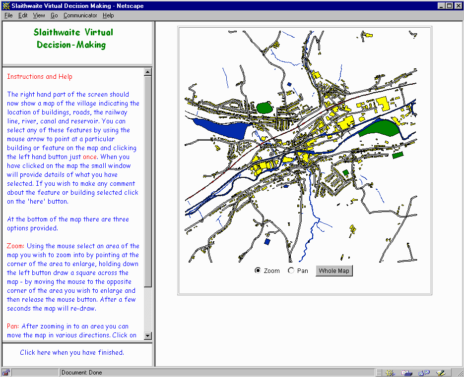
(Source:http://www.ccg.leeds.ac.uk/slaithwaite/)
The design of the system revolves around a Java map application called GeoTools (Macgill and Turton, 1998) that allows the user to perform simple spatial query and attribute input operations (see figure 2). Using this Java map applet, users can view a map of Slaithwaite, perform zoom and pan operations to assist in visualisation and navigation, ask such questions as "what is this building?" and "what is this road?" (spatial query) and then make suggestions about specific features identified from the map (attribute input). All user input is stored in the web access logs for future analysis and feedback into the planning process. In this manner a community database can be created, representing the range of views and feeling about planning issues in the locale.
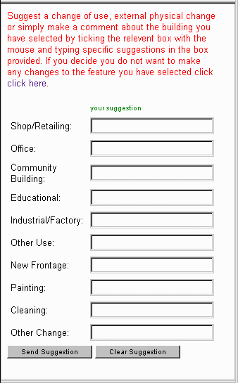
The small window in the top left hand corner of the screen displays what has been selected and the Instructions and Help window changes to a form which can be filled in with the comments and suggestions regarding the selected feature. Depending on the type of feature selected will depend on the type of form provided. If a buildings feature is selected the form illustrated in figure 3 below will be provided. Other features, such as open spaces, the river or canal provide a free form text box allowing the user to type what ever they wish. This is then sent to the system for future analysis. When the user has finished they exit the system and are provided with a series of questions asking them how they felt about using the system and they are given the opportunity to make any comments.
Figure 3: Choice Menu
National Park Reforestation
Present day forest cover in the Yorkshire Dales National Park is much reduced in comparison to the natural conditions that prevailed prior to human settlement. The Dales have been deforested and farmed intensively for hundreds of years creating a largely artificial landscape, albeit currently managed with conservation ideals in mind. With the current down trend in upland farming practices attention is being focused on conservation, habitat regeneration and leisure activities. The Yorkshire Dales National Park Authority (YDNPA) wish to increase the natural forest cover in the park by 50% over the next 25 years as part of their park wide plans for habitat regeneration. These plans are outlined in the document The Dales Woodland Strategy (YDNPA, 1995). The question remains, however, as to which areas of the park should be reforested. This is a problem best addressed by a combination of GIS, environmental modelling and public participation.
Work is underway in collaboration with the YDNPA to collate the necessary GIS data and design a web based system that will allow a wide range of user stakeholders, including local residents, farmers, land owners, park visitors and YDNPA representatives, to identify areas that are both suitable and acceptable for natural forest regeneration. This is likely to focus on a two stage approach involving GIS based modelling to identify areas best suited for regeneration of natural forest cover, and user focused participatory mapping techniques to identify which of the best suited areas are most acceptable to park residents and users. The system will be live tested on the web and via PC access points located in park visitor centres. Figure 3 below illustrates the National Park system showing land cover data with the Help and Information menu of the left hand side. The Java applet is capable of handling complex maps containing many data layers and its associated attribute information. The ability to incorporate VRML is also being investigated in this case study allowing the user to visualise their final decision in a 3-D environment after running the model to identify suitable planting areas.
Figure 4: Dales Reforestation
System
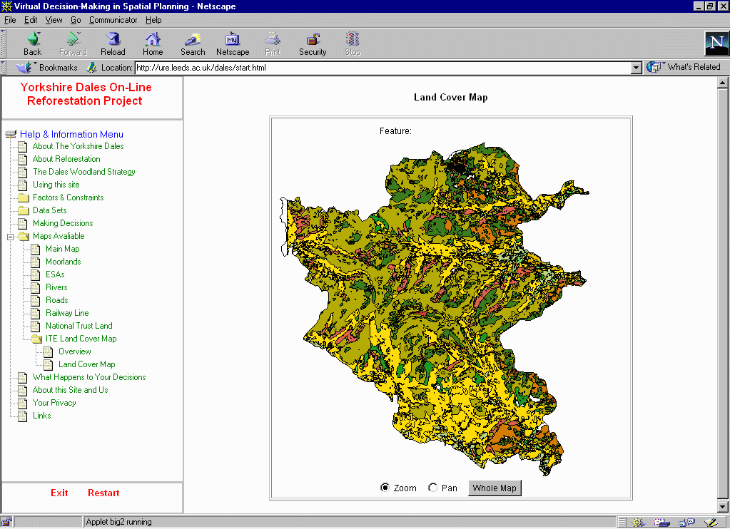
(Source: http://www.ccg.leeds.ac.uk/dales/)
Radioactive waste disposal
The third case study under development is being carried out in collaboration with United Kingdom Nirex Limited (NIREX). NIREX is the organisation entrusted with the responsibility of managing and disposing of Britains radioactive waste. Modest quantities of intermediate (ILW) and higher quantities of low level radioactive waste (LLW) have been created by the nuclear power industry, Ministry of Defence and medical/research establishments over the last 50 years.
Much of the countrys LLW have been disposed of at Drigg near Sellafield in Cumbria. This site has a limited life and ILWs have been stored pending a suitable disposal route. This creates the need for a new repository to be developed sometime in the next 50 years. Again, the question is where? Previous site searches have suffered from a lack of public participation giving rise to lack of trust. The resulting Not In My Back Yard (NIMBY) reaction and subsequent political indecision has led to several failed attempts to develop chosen sites (Openshaw et al., 1989). NIREX is now pursuing a much more open approach to the site search through increased public consultation and participation in an attempt to reach an acceptable solution.
With this in mind the project is collaborating with NIREX to develop a VDME approach to increased public involvement in the radioactive waste repository siting problem. This is building on existing work and expertise in this field. A simple VDME has existed on the web for the last three years that demonstrates the capabilities of GIS based approaches to public participation in difficult siting decisions. The current case study will further develop the principles established by the web site using more detailed and comprehensive datasets, a redesigned user interface and greater user control and input. This takes advantage of the significant improvements in web authoring tools and software, such as Java applets and advanced browser software. Data and expertise are being supplied by NIREX and the system developed here will act as a prototype for a full public consultation exercise planned by NIREX in the wake of the House of Lords Enquiry into the Management of Radioactive Waste.
Decision Processes and System Design
The flow chart in figure 5 illustrates the decision process for the Yorkshire Dales system, although similar processes are applied to both the Slaithwaite and Nirex on-line systems. The user is first presented with a request for several pieces of information to help build up a profile. This information is linked to the decisions they then make all the way through the system from start to finish. This allows decision trees to be monitored and analysed in association with the profile of the individual user providing useful insights into the decisions different types of people make. Stage 2 of the system introduces the user to the decision problem through a series of hypertext files. These can range from information explaining the data available for analysis through to the factors and constraints which need to be applied to the decision problem. This stage of the process refrains from providing any spatially referenced data as this may create a bias in a persons decisions made with regards to a particular problem. The initial text based stage of the process is intended to establish the generic rules and allows the user to build up a set of preferences in relation to the problem. If they are happy with there preferences the user then progresses on to the next stage.
Stage 3 introduces the geographical element of the decision making problem by representing relevant datasets on a map. Care needs to be taken in presenting this type of information to the user, in reality a non GIS trained public. It is likely that any reference to a GIS would confuse the user, particularly in the UK where there is little experience, if any, of publicly available GIS. The user chooses datasets which they think are important to the problem and can weight their importance accordingly. Once they are happy with their choices and decisions they run the model which interprets their choices and displays potential sites for the particular problem.
Figure 5: Decision Flow
Chart
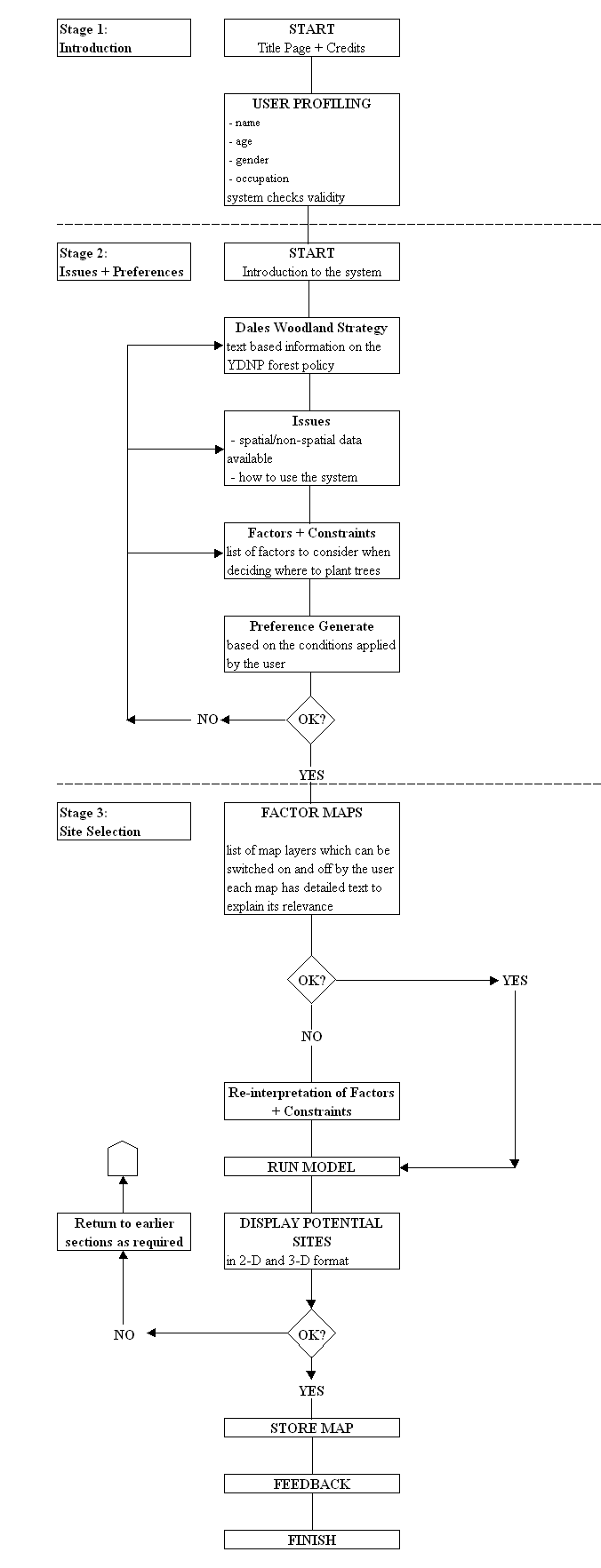
If the user is satisfied
with the outcome they can submit their idea or proposal to the system which
is stored for future use by the relevant decision making authority. It
is also possible to allow other members of the public to view what decisions
other people have made. There are several methodological and cognitive
issues regarding where in the whole process the public should be allowed
to view other peoples ideas. It could be argued that this should made
available in Stage 2 before they start weighting their choices and decisions
but it may be argued that this may cloud the judgement of many people
who may be influenced by the choices of others.
It is envisaged that through the development, application and monitoring of these three case studies at different spatial scales some of the aims and questions raised at the beginning of this paper will begin to be answered and that on-line GIS systems can be applied to other real world decisions problems.
Conclusions
The research outlined here is on-going and several important issues concerning public access to the WWW are possibly more important than the actual ability to develop systems which the public can understand and use. It needs to be recognised that access to the WWW is still relatively limited in the UK although the potential for increasing this appears to becoming a reality. These issues are discussed further in other work by Carver and Peckham (in press). The provision of public access points in council offices, libraries and community centres etc. are likely to overcome these concerns.
The research being undertaken recognises the problems associated with public access and in two of the three cases studies points of access to the Web are being provided as a method to overcome the immediate problem associated with this. If planning authorities and other decision making organisations wish to see an increase in public participation they have to realise the need to provide public access points in libraries, community centres and other public areas and buildings which the general public can easily access.
It is suggested that in particular planning problems and policy formulation process participatory on-line systems will become a useful means of informing the public and to allow access to data and planning tools such as on-line GIS as an additional means of public participation in the UK planning process. These will provide mechanisms for the exploration, experimentation and formulation of decision alternatives by the public in future planning processes and have the potential to move the public further up the participatory ladder.
Acknowledgements
This research is being undertaken in the School of Geography at the University of Leeds and is funded by the Economic and Social Research Councils Virtual Society? Programme.
References
Carver, S. (in press) Collaborative spatial decision making over the web. Transactions in GIS.
Carver, S. & Peckham, R. (in press) Internet-based applications of GIS in planning. In S. Geertman, S. Openshaw & J. Stillwell (eds.) Geographical information and planning: European perspectives. Springer-Verlag.
CCTA Government Information Service (1998) Open for Learning, Open for Business http://www.number-10.gov.uk/public/home/homepage.html, 6th November.
Devon County Council (1998) Devon County Structure Plan First Review - Deposit Version http://www.devon-cc.gov.uk/structur/
Graham, S.D.N. (1996) Flight to the Cyber Suburbs. The Guardian, April 18, pp.2-3.
Healey, P., McNamara, P., Elson, M., and Doak, A. (1988) Land Use Planning and the Mediation of Urban Change. Cambridge University Press.
Innes, J.E. and Simpson, D.M (1993) Implementing GIS for Planning. Journal of the American Planning Association, Vol. 59, No.2, pp.230-236
Keates, J.S. (1996) Understanding Maps. Addison Wesley Longman Ltd. Second Edition.
Macgill, J. and Turton, I. (1998) A Lightweight Toolkit for on-line GIS. Working Paper No.??, School of Geography, University of Leeds, UK.
MORI (1998) Internet Usage Set to Slow http://www.mori.com/polls/global98.htm Market & Opinion Research International Ltd.
NOP (1997) One in twenty five British households now linked to the Internet. http://www.nop.co.uk/internet/surveys/in07.htm NOP Research Group.
NOP (1998) Internet Research http://www.nop.co.uk/internet.asp/ NOP Research Group.
Openshaw, S., Carver, S. and Fernie, J. (1989) Britains Nuclear Waste: Safety and Siting. Belhaven Press, London.
Pickles, J. (1995) (Ed.) Ground Truth: the social implications of geographical information systems. Guildford Press: New York.
YDNPA (1995) The Dales Woodland Strategy. Yorkshire Dales National Park Authority, Leyburn.
Shiffer, M. (1995) Interactive Multimedia Planning Support: Moving from Stand Alone Systems to the World Wide Web. Environment and Planning B: Planning and Design, Vol.22, pp.649-664.
United Nations (1992) Conference on Environment and Development "Earth Summit", Rio de Janeiro, Brazil, June.
Weidemann, I. and Femers, S. (1993) Public participation in waste management decision making: analysis and management of conflicts. Journal of Hazardous Materials, Vol. 33 pp.355-368.
Wood, D. (1993) The Power of Maps. London: Routledge.
Relevant Web Pages:
Brent Council On-line Consultation http://www2.brent.gov.uk/Recycle.nsf
ESRC Virtual Society? Programme http://www.brunel.ac.uk/research/virtsoc/
Geotools http://www.ccg.leeds.ac.uk/geotools.html
Nuclear Waste Disposal http://www.ccg.leeds.ac.uk/mce/
VD-MiSP Project http://www.ccg.leeds.ac.uk/vdmisp/
Virtual Slaithwaite http://www.ccg.leeds.ac.uk/slaithwaite/
Yorkshire Dales Reforestation http://www.ccg.leeds.ac.uk/dales/